1960s Maps of Boone County, Indiana
Explore 15 historic maps of Boone County from the 1960s. These maps offer a rare glimpse into what life looked like during the 1960s — showing old roads, neighborhoods, homes, and landmarks that have changed or disappeared over time.
Whether you're researching your family's past, planning a metal detecting trip, or studying how Boone County's landscape evolved across the 1960s, these high-resolution maps are a powerful tool for exploring the history of this region.
- Focus on a specific era: All maps on this page are from the 1960s, giving you a focused view of this time period.
- See what’s changed: Compare century-old streets, trails, and buildings to today's modern landscape using overlays and satellite layers.
- Research with precision: Use these maps for genealogy, historical research, land use analysis, or educational projects.
- View, download, or print: Maps are fully viewable online in high resolution, and can be downloaded or printed for your own records.
Start exploring Boone County's history through authentic maps from the 1960s. This is your window into the past.
Boone County, IN maps
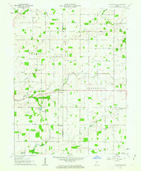
(15)- 1961 Map of Sheridan, 1962 Print
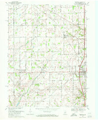
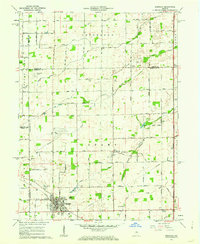 1961 Sheridan1962 Print · USGSSheridan and the surrounding Indiana farm country are captured here at the start of the 1960s, showing a landscape defined by rail and early aviation. Researchers can trace the MONON line through town or locate family sites at Crown Hill Cem, Wiles Cem, and Hills Ch.3 unique versions available
 - 1961 Map of Mechanicsburg, 1962 Print
 1961 Mechanicsburg1962 Print · USGSMid-century Boone and Clinton County life is centered around the creek-side village of Mechanicsburg and the agricultural hub of Cyclone. Researchers can trace the path of the Monon Railroad or locate local landmarks like Bethel Ch and Garrett Cem.2 unique versions available
 - 1961 Map of Kirklin, 1963 Print
 1961 Kirklin1963 Print · USGSCentral Indiana farmland thrives in the early sixties, centered on the rail-linked village of Kirklin. Researchers can trace rural life through family-named landmarks like Bogan Cem, Sedwick Chapel, and the historic MONON railroad corridor.2 unique versions available
 - 1961 Map of Hazelrigg, 1963 Print
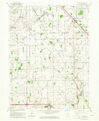
 1961 Hazelrigg1963 Print · USGSBoone County's agricultural and rail-oriented landscape is captured here in the early sixties, showing the vital connection between small towns and the New York Central Railroad. Genealogists and historians can locate family sites near Thorntown, Hazelrigg, and Dover, or trace landmarks like the Township Sch and Pleasant View Cem.2 unique versions available
 - 1961 Map of Shannondale, 1963 Print
 1961 Shannondale1963 Print · USGSCentral Indiana farm country comes into focus in the early sixties, showing the rural landscape before modern expansion. Genealogists can trace family roots through sites like Shannondale, Log Cabin Crossroads, and the Pisgah Cem.2 unique versions available
 - 1962 Map of Indianapolis
 1962 Indianapolis1962 Print · USGSCentral Indiana and the Illinois borderlands are captured here in the early sixties, showing the region's dense rail networks and growing urban centers. Genealogists and historians can locate family-named landmarks and institutions like Crown Hill Cem, Indiana University, and the Indianapolis Motor Speedway.
 - 1962 Map of Thorntown, 1963 Print
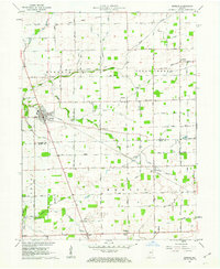
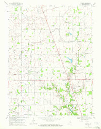
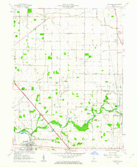 1962 Thorntown1963 Print · USGSThorntown and the surrounding Boone County farmland are captured in the early sixties as a network of rail-side settlements and rural parishes. Genealogists and local historians can trace family-named landmarks like Maple Lawn Cem, Kinder Ch, and the Old Indian Treaty Boundary.3 unique versions available
 - 1962 Map of Colfax, 1963 Print
 1962 Colfax1963 Print · USGSColfax and the surrounding rural townships are shown here in the early sixties at a peak of mid-century rail activity. Genealogists can trace family connections through numerous local burial sites including Union Cem, Shilo Cem, and Plainview Cem near the banks of Sugar Creek.2 unique versions available
 - 1962 Map of Zionsville, 1964 Print
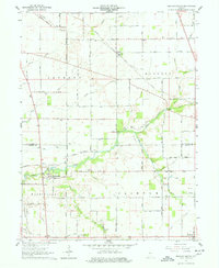
 1962 Zionsville1964 Print · USGSZionsville and the surrounding townships of Boone County are captured here in the early sixties as rural landscapes began to shift toward suburban life. Genealogists and local historians can trace family locations through numerous landmarks like McCord Cem, Salem Ch, and the settlement at Traders Point.
 - 1963 Map of Fayette, 1964 Print
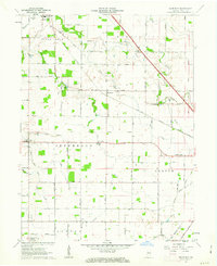
 1963 Fayette1964 Print · USGSThe rural borderlands of Boone and Hendricks counties are captured here in the early sixties, showing a landscape of family farms and small crossroad hamlets. Researchers can trace the heritage of Milledgeville and Fayette or locate ancestral sites like Bethesda Cem and Cynthiana Ch.
 - 1963 Map of Lebanon, 1965 Print
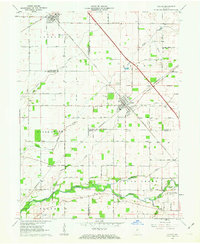
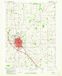 1963 Lebanon1965 Print · USGSLebanon and the surrounding Boone County farmland are captured in the early sixties as suburban growth began to branch out from the historic city core. Genealogists and local historians can trace family locations near Oak Hill Cemetery, Elizaville, and rural landmarks like Bethel Ch.3 unique versions available
 - 1966 Map of Zionsville, 1968 Print
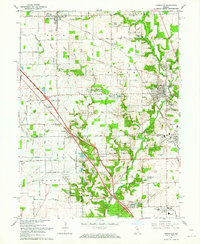
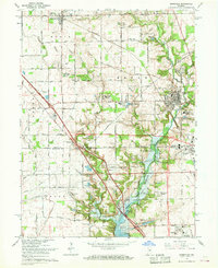 1966 Zionsville1968 Print · USGSZionsville and Whitestown are documented here in the mid-sixties, just as the landscape began to shift with the creation of the Eagle Creek Reservoir. Local historians can trace family plots at Whitestown Cem and Jones Cem or locate old landmarks like the Macedonia Ch and Pitzer Hill.5 unique versions available
 - 1967 Map of Carmel, 1969 Print
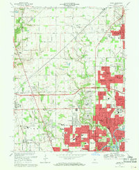 1967 Carmel1969 Print · USGSThe northern Indianapolis suburbs were rapidly expanding in the late sixties as new subdivisions began to replace farmland. Genealogists and historians can trace family locations near Eagle Village and Home Place, or locate early schools like Nora School and College Wood School.4 unique versions available
 - 1969 Map of Westfield, 1971 Print
 1969 Westfield1971 Print · USGSHamilton County farmland meets growing rural centers in the late sixties as the Monon railroad still defines the local transit corridor. Genealogists and historians can trace family locations near Union Grove Ch, Chester Cem, and the old settlement at Eagletown.2 unique versions available
 - 1969 Map of Rosston, 1972 Print
 1969 Rosston1972 Print · USGSBoone County's agricultural heartland is documented here in the late sixties, showing a landscape of strictly gridded township roads and small rural villages. Researchers can trace family history at the Parr-Jones Cem or locate the Township Sch and Indianapolis Terry Airfield.2 unique versions available
End of results
Showing maps 1-15 of 15
Top cities of Boone County
- Lebanon historical maps
- Zionsville historical maps
- Thorntown historical maps
- Jamestown historical maps
- Whitestown historical maps
- Advance historical maps
See more
Frequently asked questions
- What are the different types of historical maps available for Boone County?
- What is the oldest map of Boone County?
- Where can I purchase historical maps of Boone County for my home or office?
- Where can I download high-res historical maps of Boone County?
- Are there historical topographic maps available for Boone County?
- Is there historical aerial imagery available for Boone County?
- Where are historical maps of Boone County sourced from?