1990s Maps of Brown County, Indiana
Explore 6 historic maps of Brown County from the 1990s. These maps offer a rare glimpse into what life looked like during the 1990s — showing old roads, neighborhoods, homes, and landmarks that have changed or disappeared over time.
Whether you're researching your family's past, planning a metal detecting trip, or studying how Brown County's landscape evolved across the 1990s, these high-resolution maps are a powerful tool for exploring the history of this region.
- Focus on a specific era: All maps on this page are from the 1990s, giving you a focused view of this time period.
- See what’s changed: Compare century-old streets, trails, and buildings to today's modern landscape using overlays and satellite layers.
- Research with precision: Use these maps for genealogy, historical research, land use analysis, or educational projects.
- View, download, or print: Maps are fully viewable online in high resolution, and can be downloaded or printed for your own records.
Start exploring Brown County's history through authentic maps from the 1990s. This is your window into the past.
Brown County, IN maps
(6)- 1993 Map of Elkinsville, 1996 Print
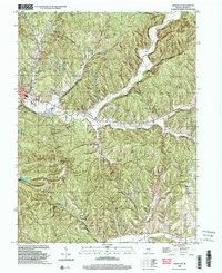
 1993 Elkinsville1996 Print · USGSBrown County's rugged ridges and the waters of the Middle Fork Salt Creek are captured here in the early 1990s. Researchers can locate the Terrill Cem, the Hickory Ridge Lookout, and the small community of Elkinsville.
 - 1998 Map of Nineveh, 2000 Print
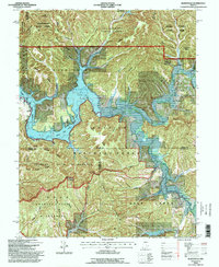
 1998 Nineveh2000 Print · USGSThe crossroads of Johnson, Brown, and Bartholomew counties are captured here in the late 1990s as military and recreational lands converge. Researchers can trace historic burial sites like the Prisoner of War Cem or explore the developed shorelines of Sweetwater Lake and Princes Lakes.
 - 1998 Map of Morgantown, 2002 Print
 1998 Morgantown2002 Print · USGSMorgan and Brown counties are captured here in the late nineties, showing a landscape defined by the deep timber of Yellowwood State Forest. Genealogists and hikers can trace the Old Railroad Grade or locate historic landmarks like the Covered Bridge and Williams Cem.
 - 1998 Map of Hindustan, 2002 Print
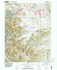
 1998 Hindustan2002 Print · USGSMonroe and Morgan counties are shown at the turn of the millennium as the terrain rises from Lake Lemon into deep forest ridges. Genealogists can trace family names through sites like Stepp Cem and the Dolan Ridge Mission or locate the historic Old Indian Treaty Boundary.
 - 1998 Map of Belmont, 2003 Print
 1998 Belmont2003 Print · USGSBrown County's rugged ridges and forest reserves are captured here at the close of the twentieth century. Genealogists and local historians can trace family land near Belmont, find the West Tollhouse, or locate rural landmarks like Hickory Hill Cem and Oak Grove Ch.
 - 1998 Map of Nashville, 2003 Print
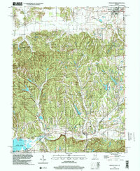
 1998 Nashville2003 Print · USGSNashville and the surrounding Brown County ridges are shown here in the late twentieth century, before modern development further altered the hollows. Genealogists can trace family footprints at Graw Bone Cem, Reeves Cem, and the old Township Sch.
End of results
Showing maps 1-6 of 6
Top cities of Brown County
Frequently asked questions
- What are the different types of historical maps available for Brown County?
- What is the oldest map of Brown County?
- Where can I purchase historical maps of Brown County for my home or office?
- Where can I download high-res historical maps of Brown County?
- Are there historical topographic maps available for Brown County?
- Is there historical aerial imagery available for Brown County?
- Where are historical maps of Brown County sourced from?