1970s Maps of Logansport, Indiana
Explore 2 historic maps of Logansport from the 1970s. These maps offer a rare glimpse into what life looked like during the 1970s — showing old roads, neighborhoods, homes, and landmarks that have changed or disappeared over time.
Whether you're researching your family's past, planning a metal detecting trip, or studying how Logansport's landscape evolved across the 1970s, these high-resolution maps are a powerful tool for exploring the history of this region.
- Focus on a specific era: All maps on this page are from the 1970s, giving you a focused view of this time period.
- See what’s changed: Compare century-old streets, trails, and buildings to today's modern landscape using overlays and satellite layers.
- Research with precision: Use these maps for genealogy, historical research, land use analysis, or educational projects.
- View, download, or print: Maps are fully viewable online in high resolution, and can be downloaded or printed for your own records.
Start exploring Logansport's history through authentic maps from the 1970s. This is your window into the past.
Logansport, IN maps
(2)- 1972 Map of Anoka, 1974 Print
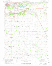 1972 Anoka1974 Print · USGSCass County in the early seventies shows the city of Logansport expanding toward the islands of the Wabash River. Genealogists and local researchers can trace family landmarks like Taber Cem, Deacon, and the Penn Central rail line.3 unique versions available
 - 1972 Map of Logansport, 1974 Print
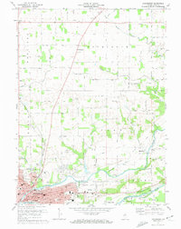 1972 Logansport1974 Print · USGSThe river-and-rail hub of Logansport is captured in the early 1970s, showing the city's growth at the confluence of the Eel and Wabash. Researchers can trace historic church sites like Bethlehem Church and local landmarks such as Wilson Gem or the Drive-in Theater.2 unique versions available
End of results
Showing maps 1-2 of 2
Top cities near Logansport
- Kokomo historical maps
- Peru historical maps
- Deer Creek historical maps
- Flora historical maps
- Galveston historical maps
- Royal Center historical maps
See more
Frequently asked questions
- What are the different types of historical maps available for Logansport?
- What is the oldest map of Logansport?
- Where can I purchase historical maps of Logansport for my home or office?
- Where can I download high-res historical maps of Logansport?
- Are there historical topographic maps available for Logansport?
- Is there historical aerial imagery available for Logansport?
- Where are historical maps of Logansport sourced from?