1960s Maps of Royal Center, Indiana
Explore 2 historic maps of Royal Center from the 1960s. These maps offer a rare glimpse into what life looked like during the 1960s — showing old roads, neighborhoods, homes, and landmarks that have changed or disappeared over time.
Whether you're researching your family's past, planning a metal detecting trip, or studying how Royal Center's landscape evolved across the 1960s, these high-resolution maps are a powerful tool for exploring the history of this region.
- Focus on a specific era: All maps on this page are from the 1960s, giving you a focused view of this time period.
- See what’s changed: Compare century-old streets, trails, and buildings to today's modern landscape using overlays and satellite layers.
- Research with precision: Use these maps for genealogy, historical research, land use analysis, or educational projects.
- View, download, or print: Maps are fully viewable online in high resolution, and can be downloaded or printed for your own records.
Start exploring Royal Center's history through authentic maps from the 1960s. This is your window into the past.
Royal Center, IN maps
(2)- 1960 Map of Lucerne, 1963 Print
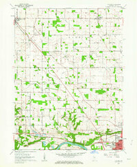 1960 Lucerne1963 Print · USGSCass County farmland meets the industrial north of Logansport in the early sixties, as the local rail and river economy transitioned for a new decade. Trace family history through landmarks like Royal Center Cem, Shiloh Ch, and the Old Indian Treaty Boundary.2 unique versions available
 - 1962 Map of Burnettsville, 1964 Print
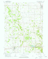 1962 Burnettsville1964 Print · USGSIndiana’s agricultural heartland is captured here in the early sixties as the borderlands of White and Cass counties were firmly established. Local historians can trace the Pennsylvania rail line past Lake Cicott and find rural landmarks like Zion Cem, Davis Cem, and the Micro-Midget Racetrack.2 unique versions available
End of results
Showing maps 1-2 of 2
Top cities near Royal Center
- Logansport historical maps
- Winamac historical maps
- Kewanna historical maps
- Burnettsville historical maps
- Yeoman historical maps
Frequently asked questions
- What are the different types of historical maps available for Royal Center?
- What is the oldest map of Royal Center?
- Where can I purchase historical maps of Royal Center for my home or office?
- Where can I download high-res historical maps of Royal Center?
- Are there historical topographic maps available for Royal Center?
- Is there historical aerial imagery available for Royal Center?
- Where are historical maps of Royal Center sourced from?