1960s Maps of Marengo, Indiana
Explore 2 historic maps of Marengo from the 1960s. These maps offer a rare glimpse into what life looked like during the 1960s — showing old roads, neighborhoods, homes, and landmarks that have changed or disappeared over time.
Whether you're researching your family's past, planning a metal detecting trip, or studying how Marengo's landscape evolved across the 1960s, these high-resolution maps are a powerful tool for exploring the history of this region.
- Focus on a specific era: All maps on this page are from the 1960s, giving you a focused view of this time period.
- See what’s changed: Compare century-old streets, trails, and buildings to today's modern landscape using overlays and satellite layers.
- Research with precision: Use these maps for genealogy, historical research, land use analysis, or educational projects.
- View, download, or print: Maps are fully viewable online in high resolution, and can be downloaded or printed for your own records.
Start exploring Marengo's history through authentic maps from the 1960s. This is your window into the past.
Marengo, IN maps
(2)- 1962 Map of Milltown, 1963 Print
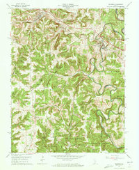 1962 Milltown1963 Print · USGSThe Blue River valley and Harrison-Crawford State Forest dominate this early 1960s landscape along the county line. Genealogists and local historians can trace rural communities through landmarks like Hogtown, St Josephs Ch, and White Cem.3 unique versions available
 - 1966 Map of Hardinsburg, 1968 Print
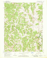 1966 Hardinsburg1968 Print · USGSSouthern Indiana's rural landscape is captured in the mid-sixties, showing the transition from agricultural tracts to protected woodlands. Genealogists can trace family sites at Baptist Hill Ch, Old Unity Ch, and the crossing at Totten Ford Bridge.2 unique versions available
End of results
Showing maps 1-2 of 2
Top cities near Marengo
- Salem historical maps
- Paoli historical maps
- Corydon historical maps
- Stampers Creek historical maps
- Palmyra historical maps
- English historical maps
See more
Frequently asked questions
- What are the different types of historical maps available for Marengo?
- What is the oldest map of Marengo?
- Where can I purchase historical maps of Marengo for my home or office?
- Where can I download high-res historical maps of Marengo?
- Are there historical topographic maps available for Marengo?
- Is there historical aerial imagery available for Marengo?
- Where are historical maps of Marengo sourced from?