1940s Maps of Midland, Indiana
Explore 2 historic maps of Midland from the 1940s. These maps offer a rare glimpse into what life looked like during the 1940s — showing old roads, neighborhoods, homes, and landmarks that have changed or disappeared over time.
Whether you're researching your family's past, planning a metal detecting trip, or studying how Midland's landscape evolved across the 1940s, these high-resolution maps are a powerful tool for exploring the history of this region.
- Focus on a specific era: All maps on this page are from the 1940s, giving you a focused view of this time period.
- See what’s changed: Compare century-old streets, trails, and buildings to today's modern landscape using overlays and satellite layers.
- Research with precision: Use these maps for genealogy, historical research, land use analysis, or educational projects.
- View, download, or print: Maps are fully viewable online in high resolution, and can be downloaded or printed for your own records.
Start exploring Midland's history through authentic maps from the 1940s. This is your window into the past.
Midland, IN maps
(2)- 1940 Map of Linton
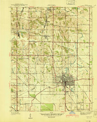 1940 Linton1940 Print · USGSLinton and its surrounding coalfields are captured in the late thirties, showcasing a landscape shaped by heavy industry and rail. Genealogists and historians can locate vanished country landmarks like Morris Chapel, Victoria, and Sassafras Sch among the early Strip Mine sites.2 unique versions available
 - 1947 Map of Linton
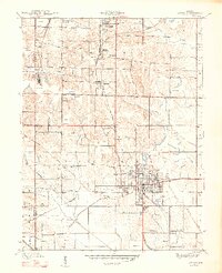 1947 Linton1947 Print · USGSGreene County is seen during a period of industrial transition in the late 1940s, when coal mining and rail transport defined the local economy. Researchers can locate family-named landmarks and rural hubs such as Wright High Sch, Antioch Ch, and the settlement of Island City.3 unique versions available
End of results
Showing maps 1-2 of 2
Top cities near Midland
- Linton historical maps
- Sullivan historical maps
- Jasonville historical maps
- Cass historical maps
- Worthington historical maps
- Shelburn historical maps
See more
Frequently asked questions
- What are the different types of historical maps available for Midland?
- What is the oldest map of Midland?
- Where can I purchase historical maps of Midland for my home or office?
- Where can I download high-res historical maps of Midland?
- Are there historical topographic maps available for Midland?
- Is there historical aerial imagery available for Midland?
- Where are historical maps of Midland sourced from?