1940s Maps of Switz City, Indiana
Explore 1 historic maps of Switz City from the 1940s. These maps offer a rare glimpse into what life looked like during the 1940s — showing old roads, neighborhoods, homes, and landmarks that have changed or disappeared over time.
Whether you're researching your family's past, planning a metal detecting trip, or studying how Switz City's landscape evolved across the 1940s, these high-resolution maps are a powerful tool for exploring the history of this region.
- Focus on a specific era: All maps on this page are from the 1940s, giving you a focused view of this time period.
- See what’s changed: Compare century-old streets, trails, and buildings to today's modern landscape using overlays and satellite layers.
- Research with precision: Use these maps for genealogy, historical research, land use analysis, or educational projects.
- View, download, or print: Maps are fully viewable online in high resolution, and can be downloaded or printed for your own records.
Start exploring Switz City's history through authentic maps from the 1940s. This is your window into the past.
Switz City, IN maps
(1)- 1947 Map of Switz City
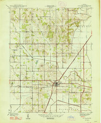 1947 Switz City1947 Print · USGSGreene County was a busy junction of rail and industry in the late 1930s, centered on the crossing of two major lines. Genealogists and researchers can trace family roots at Walker Cem, find the site of School No 6, or locate several historic Coal Mines.
End of results
Showing maps 1-1 of 1
Top cities near Switz City
- Linton historical maps
- Bloomfield historical maps
- Jasonville historical maps
- Cass historical maps
- Worthington historical maps
- Odon historical maps
See more
Frequently asked questions
- What are the different types of historical maps available for Switz City?
- What is the oldest map of Switz City?
- Where can I purchase historical maps of Switz City for my home or office?
- Where can I download high-res historical maps of Switz City?
- Are there historical topographic maps available for Switz City?
- Is there historical aerial imagery available for Switz City?
- Where are historical maps of Switz City sourced from?