1940s Maps of Laconia, Indiana
Explore 1 historic maps of Laconia from the 1940s. These maps offer a rare glimpse into what life looked like during the 1940s — showing old roads, neighborhoods, homes, and landmarks that have changed or disappeared over time.
Whether you're researching your family's past, planning a metal detecting trip, or studying how Laconia's landscape evolved across the 1940s, these high-resolution maps are a powerful tool for exploring the history of this region.
- Focus on a specific era: All maps on this page are from the 1940s, giving you a focused view of this time period.
- See what’s changed: Compare century-old streets, trails, and buildings to today's modern landscape using overlays and satellite layers.
- Research with precision: Use these maps for genealogy, historical research, land use analysis, or educational projects.
- View, download, or print: Maps are fully viewable online in high resolution, and can be downloaded or printed for your own records.
Start exploring Laconia's history through authentic maps from the 1940s. This is your window into the past.
Laconia, IN maps
(1)- 1948 Map of Laconia, 1959 Print
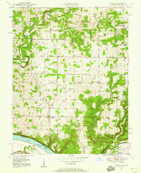 1948 Laconia1959 Print · USGSHarrison County, Indiana, sits along a winding stretch of the Ohio River in the late 1940s, serving as a vital borderland of small farms and river landings. Genealogists can locate over a dozen burial sites including Dunkard Cem and Brown Cem, alongside local hubs like Dogwood and St Michaels Ch.
End of results
Showing maps 1-1 of 1
Top cities near Laconia
- Louisville historical maps
- Radcliff historical maps
- Vine Grove historical maps
- Corydon historical maps
- Brandenburg historical maps
- Irvington historical maps
See more
Frequently asked questions
- What are the different types of historical maps available for Laconia?
- What is the oldest map of Laconia?
- Where can I purchase historical maps of Laconia for my home or office?
- Where can I download high-res historical maps of Laconia?
- Are there historical topographic maps available for Laconia?
- Is there historical aerial imagery available for Laconia?
- Where are historical maps of Laconia sourced from?