1990s Maps of LaGrange County, Indiana
Explore 6 historic maps of LaGrange County from the 1990s. These maps offer a rare glimpse into what life looked like during the 1990s — showing old roads, neighborhoods, homes, and landmarks that have changed or disappeared over time.
Whether you're researching your family's past, planning a metal detecting trip, or studying how LaGrange County's landscape evolved across the 1990s, these high-resolution maps are a powerful tool for exploring the history of this region.
- Focus on a specific era: All maps on this page are from the 1990s, giving you a focused view of this time period.
- See what’s changed: Compare century-old streets, trails, and buildings to today's modern landscape using overlays and satellite layers.
- Research with precision: Use these maps for genealogy, historical research, land use analysis, or educational projects.
- View, download, or print: Maps are fully viewable online in high resolution, and can be downloaded or printed for your own records.
Start exploring LaGrange County's history through authentic maps from the 1990s. This is your window into the past.
LaGrange County, IN maps
(6)- 1992 Map of Wolcottville, 1993 Print
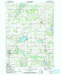 1992 Wolcottville1993 Print · USGSThe lake-dotted border of LaGrange and Noble Counties is captured here in the early nineties, showing a landscape of rural townships and summer camps. Researchers can trace local lineage through several sites like Brushy Chapel Cem, Woodland Cem, and the old rail corridor at Old RR Gr.
 - 1992 Map of Orland, 1993 Print
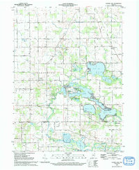
 1992 Orland1993 Print · USGSSteuben and LaGrange counties are captured here in the early nineties, showing a landscape of glacial lakes and river conservation areas. Researchers can locate local landmarks like the Fawn River Fish Hatchery, Mill Grove Cem, and Charity Ch.
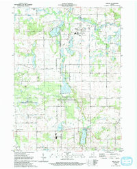
 - 1992 Map of Oliver Lake, 1993 Print
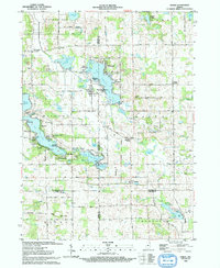
 1992 Oliver Lake1993 Print · USGSNortheastern Indiana’s lake country is captured here in the early 1990s, centered on the interconnected waters of the Elkhart River watershed. Genealogists and local historians can locate rural landmarks like the Jordan Cemetery, the settlement of Valentine, and several country schools.
 - 1992 Map of Mongo, 1993 Print
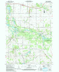 1992 Mongo1993 Print · USGSLaGrange County is defined by its winding waterways and rural crossroads during the early nineties. Genealogists and historians can trace family roots at English Prairie Cem, the Plato Mennonite Ch, and the riverside settlement of Mongo.
 - 1993 Map of Lagrange
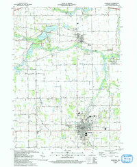 1993 Lagrange1993 Print · USGSLagrange and the village of Howe are captured in the early nineties as the region balanced its educational centers and agricultural roots. Trace local history through landmarks like the Howe Military Academy, the historic Star Mill, and several country schools like Mapel Grove Sch.
 - 1993 Map of Stroh
 1993 Stroh1993 Print · USGSNortheastern Indiana’s glaciated lake country is captured here in the early nineties, centered on the four-county junction. Trace family roots and local history at sites like Stroh, Salem Center, and the rural Weston Chapel Cem.
End of results
Showing maps 1-6 of 6
Top cities of LaGrange County
Frequently asked questions
- What are the different types of historical maps available for LaGrange County?
- What is the oldest map of LaGrange County?
- Where can I purchase historical maps of LaGrange County for my home or office?
- Where can I download high-res historical maps of LaGrange County?
- Are there historical topographic maps available for LaGrange County?
- Is there historical aerial imagery available for LaGrange County?
- Where are historical maps of LaGrange County sourced from?