1960s Maps of LaGrange County, Indiana
Explore 8 historic maps of LaGrange County from the 1960s. These maps offer a rare glimpse into what life looked like during the 1960s — showing old roads, neighborhoods, homes, and landmarks that have changed or disappeared over time.
Whether you're researching your family's past, planning a metal detecting trip, or studying how LaGrange County's landscape evolved across the 1960s, these high-resolution maps are a powerful tool for exploring the history of this region.
- Focus on a specific era: All maps on this page are from the 1960s, giving you a focused view of this time period.
- See what’s changed: Compare century-old streets, trails, and buildings to today's modern landscape using overlays and satellite layers.
- Research with precision: Use these maps for genealogy, historical research, land use analysis, or educational projects.
- View, download, or print: Maps are fully viewable online in high resolution, and can be downloaded or printed for your own records.
Start exploring LaGrange County's history through authentic maps from the 1960s. This is your window into the past.
LaGrange County, IN maps
(8)- 1960 Map of Bronson South, 1961 Print
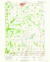 1960 Bronson South1961 Print · USGSThe Michigan-Indiana borderlands are captured here in the early sixties, showing the rural landscape between the railroad at Bronson and the Indiana Toll Road. Researchers can locate family landmarks like St Marys Cem, Greenfield Mills, and Hickory Corners Sch.2 unique versions available
 - 1960 Map of Lagrange, 1961 Print
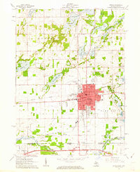
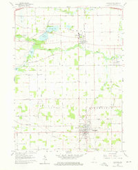 1960 Lagrange1961 Print · USGSThe Indiana lake country comes into focus in 1960 as the Lagrange county seat and the Howe Military Sch anchor the local landscape. Researchers can trace the mid-century community via Star Mill, rural schoolhouses like Green Sch, and family sites at Hoagland Cem.3 unique versions available
 - 1960 Map of Orland, 1962 Print
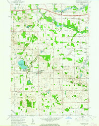
 1960 Orland1962 Print · USGSThe Indiana lake country at the turn of the sixties reveals a landscape shaped by conservation and rural community life. Genealogists and historians can trace family locations through Greenlawn Cem, East Springfield Ch, and the settlement of Orland.2 unique versions available
 - 1960 Map of Mongo, 1962 Print
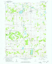
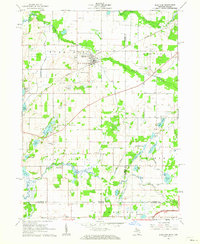
 1960 Mongo1962 Print · USGSThe LaGrange County countryside in the early sixties is defined by its glacial lakes and the winding Pigeon River. Genealogists and local historians can trace rural sites like Hoff Sch, the Bontrager Cem, and the old settlement of Mongo.2 unique versions available
 - 1961 Map of Sturgis, 1962 Print
 1961 Sturgis1962 Print · USGSSturgis and the Michigan-Indiana border are captured here at a moment of mid-century growth. Genealogists and historians can trace neighborhood schools like Holy Angels Sch, old burial grounds at Tobey Cem, and the path of the New York Central railroad.2 unique versions available
 - 1961 Map of Burr Oak, 1962 Print
 1961 Burr Oak1962 Print · USGSThe Michigan-Indiana borderlands are captured here in the early sixties, showing the agricultural and rail-oriented life of the region. Researchers can locate many family-history sites like Dutch Settlement Cem, Burr Oak, and the Fawn River Sch.2 unique versions available
 - 1961 Map of Shipshewana, 1963 Print
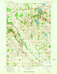
 1961 Shipshewana1963 Print · USGSLaGrange County, Indiana, is captured here in the early sixties as the modern interstate era meets traditional farming life. Genealogists and local historians can trace family-named sites like the Sidener Cem, Wolfe Field, and the Newberry-Van Buren Twp Sch.
 - 1961 Map of Middlebury, 1964 Print
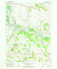
 1961 Middlebury1964 Print · USGSIn the early sixties, the Elkhart and LaGrange county borderlands were transitioning as a new interstate toll road met established rail lines. Genealogists can trace rural family roots at Grace Lawn Cemetery, Bontrager Cemetery, and the Stone Lake Community Church.3 unique versions available
End of results
Showing maps 1-8 of 8
Top cities of LaGrange County
Frequently asked questions
- What are the different types of historical maps available for LaGrange County?
- What is the oldest map of LaGrange County?
- Where can I purchase historical maps of LaGrange County for my home or office?
- Where can I download high-res historical maps of LaGrange County?
- Are there historical topographic maps available for LaGrange County?
- Is there historical aerial imagery available for LaGrange County?
- Where are historical maps of LaGrange County sourced from?