1950s Maps of Center Township, Indiana
Explore 6 historic maps of Center Township from the 1950s. These maps offer a rare glimpse into what life looked like during the 1950s — showing old roads, neighborhoods, homes, and landmarks that have changed or disappeared over time.
Whether you're researching your family's past, planning a metal detecting trip, or studying how Center Township's landscape evolved across the 1950s, these high-resolution maps are a powerful tool for exploring the history of this region.
- Focus on a specific era: All maps on this page are from the 1950s, giving you a focused view of this time period.
- See what’s changed: Compare century-old streets, trails, and buildings to today's modern landscape using overlays and satellite layers.
- Research with precision: Use these maps for genealogy, historical research, land use analysis, or educational projects.
- View, download, or print: Maps are fully viewable online in high resolution, and can be downloaded or printed for your own records.
Start exploring Center Township's history through authentic maps from the 1950s. This is your window into the past.
Center Township, IN maps
(6)- 1953 Map of Leroy, 1955 Print
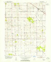 1953 Leroy1955 Print · USGSSouthern Lake County's agricultural heartland is captured here in the early 1950s as a complex system of drainage ditches reclaimed the prairie. Researchers can pinpoint long-standing landmarks including Leroy, the Riley Sch, and Plum Grove Cem.
 - 1953 Map of St. John, 1955 Print
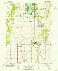
 1953 St. John1955 Print · USGSNorthwest Indiana during the early fifties reveals a landscape where historic rail lines and the Lincoln Highway meet growing lakeside communities. Genealogists and local historians can trace family-named sites like Dutton Cem and Hack Cem, or locate mid-century landmarks such as the Illiana Race Track.
 - 1953 Map of Crown Point, 1955 Print
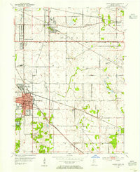 1953 Crown Point1955 Print · USGSLake County is captured in the early fifties as a landscape of established rail hubs and emerging suburbs connected by the historic Lincoln Highway. Researchers can trace local roots at the Bail School, Maplewood Cemetery, and the old County Fairground.
 - 1953 Map of Lowell, 1955 Print
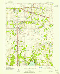
 1953 Lowell1955 Print · USGSSouthern Lake County in the early 1950s is defined by its evolving rail corridors and lakeside settlements. Genealogists can trace rural family life through locations like Sheridan School, St Edwards Cemetery, and the rail stops at North Hayden or Creston.
 - 1953 Map of Chicago, 1964 Print
 1953 Chicago1964 Print · USGSThe southern Lake Michigan shoreline was rapidly modernizing in the mid-fifties, balancing heavy industry with its famous academic centers. Researchers can trace the footprints of Notre Dame University or locate vanished sites like the Kingsbury Ordnance Plant and Meigs Field.5 unique versions available
 - 1957 Map of Chicago
 1957 Chicago1957 Print · USGSThe industrial heartland and southern Great Lakes shoreline are captured here during the peak of mid-century growth. Researchers can trace the massive Gary Steel Works, the grounds of the University of Notre Dame, and the early paths of the Tri-State Tollway.
End of results
Showing maps 1-6 of 6
Top cities near Center Township
- Hammond historical maps
- Gary historical maps
- Portage historical maps
- Calumet City historical maps
- Merrillville historical maps
- Lansing historical maps
See more
Top neighborhoods of Center Township
Frequently asked questions
- What are the different types of historical maps available for Center Township?
- What is the oldest map of Center Township?
- Where can I purchase historical maps of Center Township for my home or office?
- Where can I download high-res historical maps of Center Township?
- Are there historical topographic maps available for Center Township?
- Is there historical aerial imagery available for Center Township?
- Where are historical maps of Center Township sourced from?