1990s Maps of Latitude, Winfield
Explore 2 historic maps of Latitude from the 1990s. These maps offer a rare glimpse into what life looked like during the 1990s — showing old roads, neighborhoods, homes, and landmarks that have changed or disappeared over time.
Whether you're researching your family's past, planning a metal detecting trip, or studying how Latitude's landscape evolved across the 1990s, these high-resolution maps are a powerful tool for exploring the history of this region.
- Focus on a specific era: All maps on this page are from the 1990s, giving you a focused view of this time period.
- See what’s changed: Compare century-old streets, trails, and buildings to today's modern landscape using overlays and satellite layers.
- Research with precision: Use these maps for genealogy, historical research, land use analysis, or educational projects.
- View, download, or print: Maps are fully viewable online in high resolution, and can be downloaded or printed for your own records.
Start exploring Latitude's history through authentic maps from the 1990s. This is your window into the past.
Latitude, Winfield maps
(2)- 1991 Map of Kankakee
 1991 Kankakee1991 Print · USGSThe Illinois-Indiana borderlands come into focus during the early nineties, centered on the growing Kankakee valley and its sprawling drainage systems. Trace the rail-and-river economy through landmarks like the Wilton Railroad Grade, the Manteno State Hospital, and the historic Old Pioneer Cem.
 - 1992 Map of Palmer
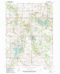 1992 Palmer1992 Print · USGSNorthwest Indiana near the turn of the millennium shows a transition from quiet rural townships to growing lakeside communities. Researchers can locate family roots at Mosier Cem or trace the early development surrounding Lake Eliza and Holiday Lake.
End of results
Showing maps 1-2 of 2
Frequently asked questions
- What are the different types of historical maps available for Latitude?
- What is the oldest map of Latitude?
- Where can I purchase historical maps of Latitude for my home or office?
- Where can I download high-res historical maps of Latitude?
- Are there historical topographic maps available for Latitude?
- Is there historical aerial imagery available for Latitude?
- Where are historical maps of Latitude sourced from?