1960s Maps of Alexandria, Indiana
Explore 2 historic maps of Alexandria from the 1960s. These maps offer a rare glimpse into what life looked like during the 1960s — showing old roads, neighborhoods, homes, and landmarks that have changed or disappeared over time.
Whether you're researching your family's past, planning a metal detecting trip, or studying how Alexandria's landscape evolved across the 1960s, these high-resolution maps are a powerful tool for exploring the history of this region.
- Focus on a specific era: All maps on this page are from the 1960s, giving you a focused view of this time period.
- See what’s changed: Compare century-old streets, trails, and buildings to today's modern landscape using overlays and satellite layers.
- Research with precision: Use these maps for genealogy, historical research, land use analysis, or educational projects.
- View, download, or print: Maps are fully viewable online in high resolution, and can be downloaded or printed for your own records.
Start exploring Alexandria's history through authentic maps from the 1960s. This is your window into the past.
Alexandria, IN maps
(2)- 1960 Map of Alexandria, 1961 Print
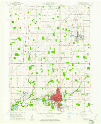 1960 Alexandria1961 Print · USGSMadison County, Indiana, is captured here at the dawn of the sixties, showcasing the thriving railroad and farming hub of Alexandria. Researchers can trace the legacy of family farms and rural life through landmarks like Forrestville Cem, Cunningham Sch, and the town of Orestes.3 unique versions available
 - 1960 Map of Anderson North, 1961 Print
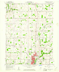 1960 Anderson North1961 Print · USGSMadison County in the early sixties shows the suburban growth of Anderson and Alexandria amidst a landscape of rural schools and family chapels. Genealogists can trace property near Wesley Chapel, Donahue Cem, and the village of Prosperity.5 unique versions available
End of results
Showing maps 1-2 of 2
Top cities near Alexandria
- Noblesville historical maps
- Muncie historical maps
- Anderson historical maps
- Marion historical maps
- Elwood historical maps
- Gas City historical maps
See more
Top neighborhoods of Alexandria
Frequently asked questions
- What are the different types of historical maps available for Alexandria?
- What is the oldest map of Alexandria?
- Where can I purchase historical maps of Alexandria for my home or office?
- Where can I download high-res historical maps of Alexandria?
- Are there historical topographic maps available for Alexandria?
- Is there historical aerial imagery available for Alexandria?
- Where are historical maps of Alexandria sourced from?