Old Maps of Garfield Park, Indianapolis for Genealogy
Trace your family roots with 14 historic maps of Garfield Park. These high-res maps reveal old neighborhoods, homesites, landmarks, and streets — helping you uncover where your ancestors lived and how the area evolved over time.
- Explore historic neighborhoods: Identify where your relatives may have lived in the 1800s or 1900s.
- Compare maps over time: Trace the changes in streets, buildings, and landmarks for multi-generational research.
- Perfect for genealogy & ancestry research: Used by family historians and researchers to map out lineage and migration.
These maps are an incredible resource for exploring your personal connection to Garfield Park's past.
Garfield Park, Indianapolis maps
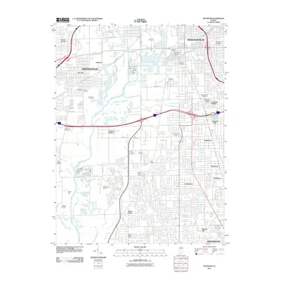
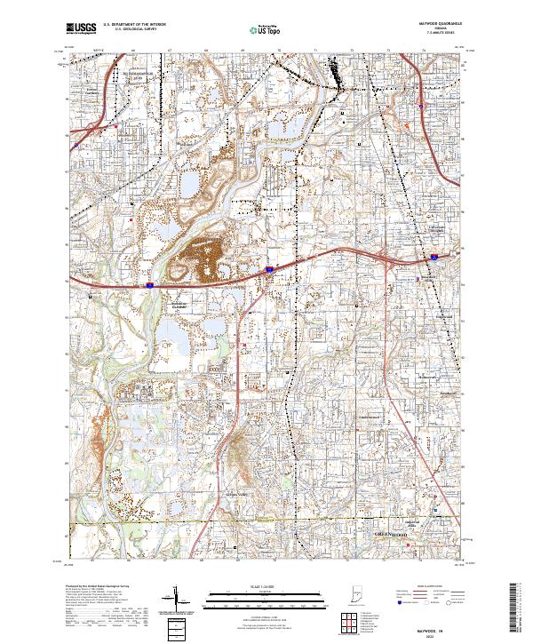
(14)- 1948 Map of Maywood
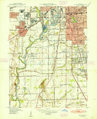 1948 Maywood1948 Print · USGSThe southern suburbs of Indianapolis are captured here in the post-war era as industrial centers and new neighborhoods expand toward the county line. Genealogists and historians can trace the foundations of Mars Hill, explore the campus of Indiana Central College, or locate family sites at Holy Cross Cem.2 unique versions available
 - 1953 Map of Indianapolis, 1965 Print
 1953 Indianapolis1965 Print · USGSCentral Indiana and the Illinois borderlands are captured in the mid-sixties, showing the growth of Indianapolis and its industrial rail corridors. Genealogists and historians can trace the development of outlying towns like Zionsville or Beech Grove and find landmarks such as Atterbury AAF and Turkey Run State Park.4 unique versions available
 - 1956 Map of Indianapolis
 1956 Indianapolis1956 Print · USGSCentral Indiana in the mid-fifties is captured during a period of industrial growth and military presence. Genealogists and historians can trace the rail networks of the New York Central or locate regional landmarks like Fort Benjamin Harrison and Camp Atterbury.
 - 1957 Map of Indianapolis
 1957 Indianapolis1957 Print · USGSCentral Indiana in the mid-fifties is captured here as a crossroads of major rail lines and nascent federal highways. Genealogists and historians can trace family-named ridges like Poplar Ridge or locate strategic sites like Camp Atterbury and Speedway.2 unique versions available
 - 1959 Map of Maywood, 1961 Print
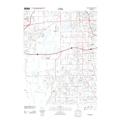
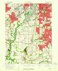 1959 Maywood1961 Print · USGSThe southern suburbs of Indianapolis and northern Johnson County are captured here during a period of rapid post-war growth. Researchers can trace family history through numerous landmarks like Indiana Central College, Union Stockyards, and Southport High Sch.
 - 1962 Map of Indianapolis
 1962 Indianapolis1962 Print · USGSCentral Indiana and the Illinois borderlands are captured here in the early sixties, showing the region's dense rail networks and growing urban centers. Genealogists and historians can locate family-named landmarks and institutions like Crown Hill Cem, Indiana University, and the Indianapolis Motor Speedway.
 - 1967 Map of Maywood, 1969 Print
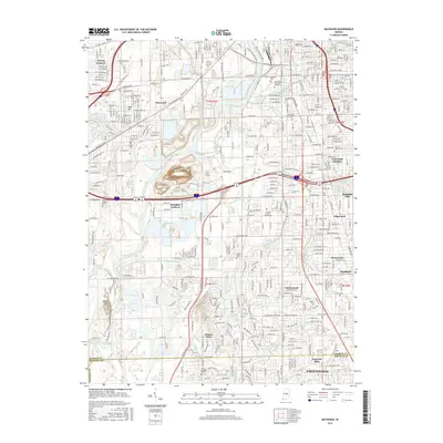
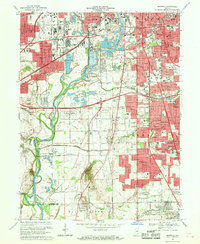 1967 Maywood1969 Print · USGSMarion County's southern industrial and residential sprawl is captured here in the late sixties as the city pushed toward the Johnson County line. Researchers can trace family roots at Indiana Central College, locate the old Union Stockyards, or find records at Calvary Cemetery.3 unique versions available
 - 1986 Map of Indianapolis
 1986 Indianapolis1986 Print · USGSThe Indiana capital and its surrounding counties are captured here in the mid-1980s, showcasing the height of its orbital highway development and suburban growth. Researchers can trace the legacy of the Fort Benjamin Harrison Military Reservation, follow the Conrail lines, or locate family roots in Beech Grove, Greencastle, and Zionsville.2 unique versions available
 - 1998 Map of Maywood, 2002 Print
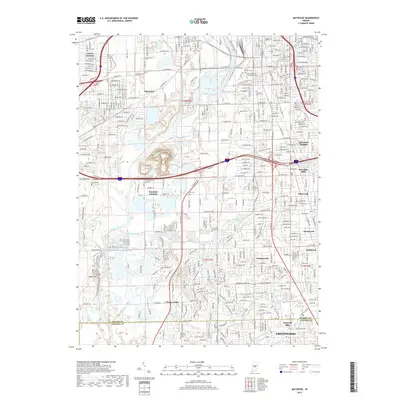
 1998 Maywood2002 Print · USGSThe southern suburbs of Indianapolis and the White River valley are captured here in the late 1990s as residential growth meets legacy industry. Researchers can locate family roots at Hebrew Cemetery or trace the early footprint of Indiana Central College and Stout Field.
 - 2011 Map of Maywood, 2011 Print
 2011 Maywood2011 Print · USGSCovers Garfield Park, including Indianapolis, Greenwood, and other nearby areas
 - 2013 Map of Maywood, 2013 Print
 2013 Maywood2013 Print · USGSCovers Garfield Park, including Indianapolis, Greenwood, and other nearby areas
 - 2016 Map of Maywood, 2016 Print
 2016 Maywood2016 Print · USGSCovers Garfield Park, including Indianapolis, Greenwood, and other nearby areas
 - 2019 Map of Maywood, 2019 Print
 2019 Maywood2019 Print · USGSCovers Garfield Park, including Indianapolis, Greenwood, and other nearby areas
 - 2022 Map of Maywood, 2022 Print
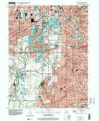
 2022 Maywood2022 Print · USGSSouth of Indianapolis in the early 2020s, the river and rail corridors weave through long-established neighborhoods and expansive cemeteries. Genealogists and local historians can trace the grounds of Calvary Cemetery or locate the historic campus of the University of Indianapolis.
End of results
Showing maps 1-14 of 14
Frequently asked questions
- What are the different types of historical maps available for Garfield Park?
- What is the oldest map of Garfield Park?
- Where can I purchase historical maps of Garfield Park for my home or office?
- Where can I download high-res historical maps of Garfield Park?
- Are there historical topographic maps available for Garfield Park?
- Is there historical aerial imagery available for Garfield Park?
- Where are historical maps of Garfield Park sourced from?