1990s Maps of St. Clair Place, Near Eastside
Explore 2 historic maps of St. Clair Place from the 1990s. These maps offer a rare glimpse into what life looked like during the 1990s — showing old roads, neighborhoods, homes, and landmarks that have changed or disappeared over time.
Whether you're researching your family's past, planning a metal detecting trip, or studying how St. Clair Place's landscape evolved across the 1990s, these high-resolution maps are a powerful tool for exploring the history of this region.
- Focus on a specific era: All maps on this page are from the 1990s, giving you a focused view of this time period.
- See what’s changed: Compare century-old streets, trails, and buildings to today's modern landscape using overlays and satellite layers.
- Research with precision: Use these maps for genealogy, historical research, land use analysis, or educational projects.
- View, download, or print: Maps are fully viewable online in high resolution, and can be downloaded or printed for your own records.
Start exploring St. Clair Place's history through authentic maps from the 1990s. This is your window into the past.
St. Clair Place, Near Eastside maps
(2)- 1998 Map of Indianapolis East, 2001 Print
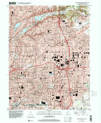 1998 Indianapolis East2001 Print · USGSMarion County’s eastern suburbs and urban neighborhoods are captured here in the late nineties as a fully realized landscape of industry and community. Researchers can locate dozens of parish schools and historic burial grounds like Fall Creek Cemetery or trace the sprawling U S Naval Reservation.
 - 1998 Map of Indianapolis West, 2002 Print
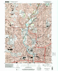 1998 Indianapolis West2002 Print · USGSIndianapolis and the town of Speedway are shown at a peak of late-century development, where the river meets the rail lines of CONRAIL. Trace historic school sites like Attucks High Sch and the expansive grounds of Crown Hill Cemetery.
End of results
Showing maps 1-2 of 2
Frequently asked questions
- What are the different types of historical maps available for St. Clair Place?
- What is the oldest map of St. Clair Place?
- Where can I purchase historical maps of St. Clair Place for my home or office?
- Where can I download high-res historical maps of St. Clair Place?
- Are there historical topographic maps available for St. Clair Place?
- Is there historical aerial imagery available for St. Clair Place?
- Where are historical maps of St. Clair Place sourced from?