1960s Maps of St. Clair Place, Near Eastside
Explore 3 historic maps of St. Clair Place from the 1960s. These maps offer a rare glimpse into what life looked like during the 1960s — showing old roads, neighborhoods, homes, and landmarks that have changed or disappeared over time.
Whether you're researching your family's past, planning a metal detecting trip, or studying how St. Clair Place's landscape evolved across the 1960s, these high-resolution maps are a powerful tool for exploring the history of this region.
- Focus on a specific era: All maps on this page are from the 1960s, giving you a focused view of this time period.
- See what’s changed: Compare century-old streets, trails, and buildings to today's modern landscape using overlays and satellite layers.
- Research with precision: Use these maps for genealogy, historical research, land use analysis, or educational projects.
- View, download, or print: Maps are fully viewable online in high resolution, and can be downloaded or printed for your own records.
Start exploring St. Clair Place's history through authentic maps from the 1960s. This is your window into the past.
St. Clair Place, Near Eastside maps
(3)- 1962 Map of Indianapolis
 1962 Indianapolis1962 Print · USGSCentral Indiana and the Illinois borderlands are captured here in the early sixties, showing the region's dense rail networks and growing urban centers. Genealogists and historians can locate family-named landmarks and institutions like Crown Hill Cem, Indiana University, and the Indianapolis Motor Speedway.
 - 1967 Map of Indianapolis West, 1969 Print
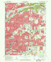
 1967 Indianapolis West1969 Print · USGSMid-century Indianapolis comes alive in this survey of the city's west side and the growing western townships. Researchers can trace historic institutions and neighborhoods like Rocky Ripple and Broadmoor, or locate family sites at CROWN HILL CEMETERY and Floral Park Cem.5 unique versions available
 - 1967 Map of Indianapolis East, 1970 Print
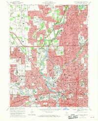
 1967 Indianapolis East1970 Print · USGSMarion County's eastern neighborhoods and military grounds are captured here in the late sixties as suburban development expands toward the Lawrence area. Researchers can trace local genealogy through numerous institutions like Scecina High Sch or find industrial roots at the Hawthorne Yards.3 unique versions available
End of results
Showing maps 1-3 of 3
Frequently asked questions
- What are the different types of historical maps available for St. Clair Place?
- What is the oldest map of St. Clair Place?
- Where can I purchase historical maps of St. Clair Place for my home or office?
- Where can I download high-res historical maps of St. Clair Place?
- Are there historical topographic maps available for St. Clair Place?
- Is there historical aerial imagery available for St. Clair Place?
- Where are historical maps of St. Clair Place sourced from?