1980s Maps of Dead Mans Crossing, Indiana
Explore 2 historic maps of Dead Mans Crossing from the 1980s. These maps offer a rare glimpse into what life looked like during the 1980s — showing old roads, neighborhoods, homes, and landmarks that have changed or disappeared over time.
Whether you're researching your family's past, planning a metal detecting trip, or studying how Dead Mans Crossing's landscape evolved across the 1980s, these high-resolution maps are a powerful tool for exploring the history of this region.
- Focus on a specific era: All maps on this page are from the 1980s, giving you a focused view of this time period.
- See what’s changed: Compare century-old streets, trails, and buildings to today's modern landscape using overlays and satellite layers.
- Research with precision: Use these maps for genealogy, historical research, land use analysis, or educational projects.
- View, download, or print: Maps are fully viewable online in high resolution, and can be downloaded or printed for your own records.
Start exploring Dead Mans Crossing's history through authentic maps from the 1980s. This is your window into the past.
Dead Mans Crossing, IN maps
(2)- 1981 Map of Mount Vernon
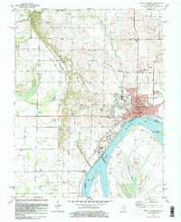 1981 Mount Vernon1981 Print · USGSMount Vernon and the winding Ohio River shoreline appear here in the early eighties, capturing a landscape of active river industry and rural family life. Genealogists can trace sites like Belle Fontaine Cem, Zoar Ch, and the defunct Dead Mans Crossing along the rail lines.
 - 1986 Map of Evansville
 1986 Evansville1986 Print · USGSThe Ohio River valley thrives in the mid-1980s as a hub of river commerce, industry, and natural preservation spanning the Indiana-Kentucky border. Genealogists and historians can locate remote landmarks like Dead Mans Cem, Lippe Church, and the riverside community of Scuffletown.
End of results
Showing maps 1-2 of 2
Top cities near Dead Mans Crossing
- Mount Vernon historical maps
- Poseyville historical maps
- Uniontown historical maps
- New Harmony historical maps
- Corydon historical maps
- Crossville historical maps
See more
Frequently asked questions
- What are the different types of historical maps available for Dead Mans Crossing?
- What is the oldest map of Dead Mans Crossing?
- Where can I purchase historical maps of Dead Mans Crossing for my home or office?
- Where can I download high-res historical maps of Dead Mans Crossing?
- Are there historical topographic maps available for Dead Mans Crossing?
- Is there historical aerial imagery available for Dead Mans Crossing?
- Where are historical maps of Dead Mans Crossing sourced from?