Old Maps of South Bend, Indiana
Explore 16 old maps of South Bend, spanning from 1927 to today. These high-resolution historic maps reveal how streets, neighborhoods, landmarks, and natural features evolved over time — perfect for genealogy, metal detecting, research, and local history exploration.
What you can do with these maps:
- See how South Bend changed over time: Compare historical maps to modern-day views to trace roads, homesites, rail lines & more.
- View detailed metadata: Each map includes creators, publishers, year, scale, and archive source.
- Overlay maps with satellite & LiDAR: Visualize the past alongside modern tools to explore terrain & human change.
- Trusted historical sources: Maps sourced from the USGS, Library of Congress, and other archives.
- Access maps your way: View online, download high-res files, or order prints for personal or research use.
Start exploring old maps of South Bend to uncover forgotten places, hidden landmarks, and the deep history beneath your feet.
South Bend, IN maps
(16)- 1927 Map of Niles
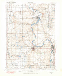 1927 Niles1927 Print · USGSCovers South Bend, including Niles, Buchanan, and other nearby areas
 - 1930 Map of Niles
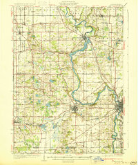 1930 Niles1930 Print · USGSCovers South Bend, including Niles, Buchanan, and other nearby areas4 unique versions available
 - 1943 Map of Niles
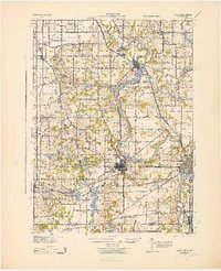 1943 Niles1943 Print · USGSCovers South Bend, including Niles, Buchanan, and other nearby areas
 - 1953 Map of Chicago, 1964 Print
 1953 Chicago1964 Print · USGSCovers South Bend, including Chicago, Joliet, and other nearby areas5 unique versions available
 - 1957 Map of Chicago
 1957 Chicago1957 Print · USGSCovers South Bend, including Chicago, Joliet, and other nearby areas
 - 1958 Map of South Bend East, 1959 Print
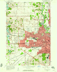
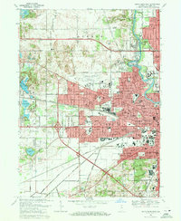
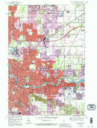
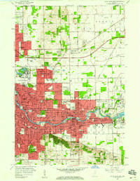 1958 South Bend East1959 Print · USGSCovers South Bend, including Mishawaka, Notre Dame, and other nearby areas
 - 1958 Map of South Bend West, 1959 Print
 1958 South Bend West1959 Print · USGSCovers South Bend, including Roseland, Ardmore, and other nearby areas
 - 1958 Map of Lakeville, 1964 Print
 1958 Lakeville1964 Print · USGSCovers South Bend, including Lakeville, Colburn, and other nearby areas
 - 1961 Map of Wyatt, 1964 Print
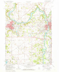
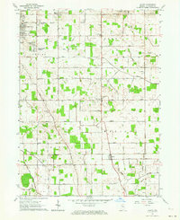 1961 Wyatt1964 Print · USGSCovers South Bend, including Mishawaka, Tamarack Grange, and other nearby areas2 unique versions available
 - 1969 Map of South Bend East, 1971 Print
 1969 South Bend East1971 Print · USGSCovers South Bend, including Mishawaka, Notre Dame, and other nearby areas4 unique versions available
 - 1969 Map of South Bend West, 1971 Print
 1969 South Bend West1971 Print · USGSCovers South Bend, including Roseland, Ardmore, and other nearby areas4 unique versions available
 - 1971 Map of Niles West, 1973 Print
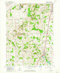
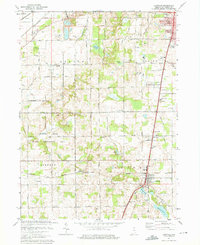
 1971 Niles West1973 Print · USGSCovers South Bend, including Niles, Buchanan, and other nearby areas2 unique versions available
 - 1974 Map of Lakeville, 1975 Print
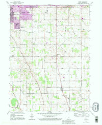
 1974 Lakeville1975 Print · USGSCovers South Bend, including Lakeville, Colburn, and other nearby areas2 unique versions available
 - 1983 Map of South Bend, 1984 Print
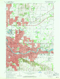
 1983 South Bend1984 Print · USGSCovers South Bend, including Elkhart, Mishawaka, and other nearby areas2 unique versions available
 - 1992 Map of Wyatt, 1995 Print
 1992 Wyatt1995 Print · USGSCovers South Bend, including Mishawaka, Tamarack Grange, and other nearby areas
 - 1992 Map of South Bend East, 1995 Print
 1992 South Bend East1995 Print · USGSCovers South Bend, including Mishawaka, Notre Dame, and other nearby areas
End of results
Showing maps 1-16 of 16
Top cities near South Bend
- Mishawaka historical maps
- Granger historical maps
- Niles historical maps
- Notre Dame historical maps
- Olive historical maps
- Bremen historical maps
See more
Top neighborhoods of South Bend
- Crest Manor Addition historical maps
- Bercliff Estates historical maps
- Eddy Street Commons historical maps
- Edgewater historical maps
- Edison Park historical maps
- Keller Park historical maps
See more
Frequently asked questions
- What are the different types of historical maps available for South Bend?
- What is the oldest map of South Bend?
- Where can I purchase historical maps of South Bend for my home or office?
- Where can I download high-res historical maps of South Bend?
- Are there historical topographic maps available for South Bend?
- Is there historical aerial imagery available for South Bend?
- Where are historical maps of South Bend sourced from?