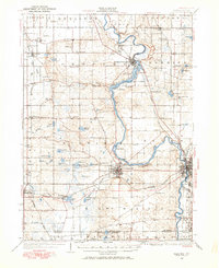
1927 Map of Niles
USGS Topo · Published 1927About this map
St Joseph River snakes through the center of this landscape, its path widened by the reservoir of Chapin Lake and guarded by the grounds of Emmanuel Missionary College. The region is defined by a dense network of early 20th-century rural infrastructure, where nearly every section corner features a local schoolhouse such as Bedinger Sch, Shaunee Sch, or Rittinger Sch. These school districts and local churches, like Salem Ch, served the farming communities clustered around rail lines and river bends before mid-century consolidation.
Find a feature on this map
120 named features on this map. Tap any name to fly to it.
Don’t see what you’re looking for? This feature index may not catch every label — zoom into the map to look around manually.
Map Details
Editions of this 1927 Niles Map
This is the sole edition of this map. No revisions or reprints were ever made.
Historical Maps of South Bend Through Time
Featured Locations
- South Bend, IN
- Buchanan, MI
- Niles, MI
- Berrien Springs, Oronoko Charter Township
- Bertrand, Bertrand Township