1900s (20th Century) Maps of Hamlet, Indiana
Explore 7 historic maps of Hamlet from the 1900s (20th Century). These maps offer a rare glimpse into what life looked like during the 1900s — showing old roads, neighborhoods, homes, and landmarks that have changed or disappeared over time.
Whether you're researching your family's past, planning a metal detecting trip, or studying how Hamlet's landscape evolved across the 1900s, these high-resolution maps are a powerful tool for exploring the history of this region.
- Focus on a specific era: All maps on this page are from the 1900s, giving you a focused view of this time period.
- See what’s changed: Compare century-old streets, trails, and buildings to today's modern landscape using overlays and satellite layers.
- Research with precision: Use these maps for genealogy, historical research, land use analysis, or educational projects.
- View, download, or print: Maps are fully viewable online in high resolution, and can be downloaded or printed for your own records.
Start exploring Hamlet's history through authentic maps from the 1900s. This is your window into the past.
Hamlet, IN maps
(7)- 1953 Map of Chicago, 1964 Print
 1953 Chicago1964 Print · USGSThe southern Lake Michigan shoreline was rapidly modernizing in the mid-fifties, balancing heavy industry with its famous academic centers. Researchers can trace the footprints of Notre Dame University or locate vanished sites like the Kingsbury Ordnance Plant and Meigs Field.5 unique versions available
 - 1957 Map of Chicago
 1957 Chicago1957 Print · USGSThe industrial heartland and southern Great Lakes shoreline are captured here during the peak of mid-century growth. Researchers can trace the massive Gary Steel Works, the grounds of the University of Notre Dame, and the early paths of the Tri-State Tollway.
 - 1957 Map of Knox East, 1958 Print
 1957 Knox East1958 Print · USGSStarke County near KNOX and Grovertown is seen here in the mid-1950s, defined by its river-fed drainage and crossing rail lines. Genealogists can trace family landmarks like Crown Hill Cemetery, Eagle Creek Church, and Swartzell Cemetery.
 - 1958 Map of Hamlet, 1960 Print
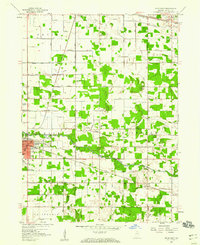
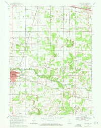
 1958 Hamlet1960 Print · USGSRailroad hubs and reclaimed marshlands define this part of Starke County in the late fifties. Genealogists and local historians can trace the intricate network of family-named drainage lines like Amy Kelley Ditch and rail stops at Hamlet and Grovertown.
 - 1969 Map of Knox East, 1971 Print
 1969 Knox East1971 Print · USGSStarke County is captured in the late sixties as the city of Knox expands along the Yellow River. Genealogists can trace family roots through numerous landmarks like Crown Hill Cemetery, St. Mathews Church, and the rural outpost of Grovertown.2 unique versions available
 - 1969 Map of Hamlet, 1971 Print
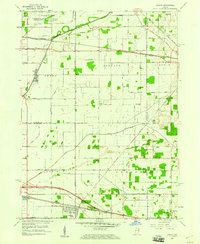
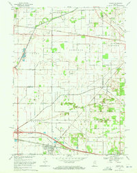 1969 Hamlet1971 Print · USGSStarke and La Porte counties are captured here in the late sixties as the rail-centered economy of Hamlet remained the focal point of the local landscape. Genealogists and researchers can trace the Penn Central lines, the historic Yellowstone Trail, and landmarks like the Township Sch and Grovertown.2 unique versions available
 - 1984 Map of Knox, 1985 Print
 1984 Knox1985 Print · USGSNorthern Indiana's glacial lake country is captured in the mid-eighties, showing a landscape defined by the Kankakee River and major rail lines. Genealogists and historians can trace family ties through lakefront settlements like Lake Maxinkuckee and Bass Lake or the Old Indian Treaty Boundary.2 unique versions available
End of results
Showing maps 1-7 of 7
Top cities near Hamlet
- South Bend historical maps
- La Porte historical maps
- Plymouth historical maps
- Kankakee historical maps
- Knox historical maps
- Walkerton historical maps
See more
Frequently asked questions
- What are the different types of historical maps available for Hamlet?
- What is the oldest map of Hamlet?
- Where can I purchase historical maps of Hamlet for my home or office?
- Where can I download high-res historical maps of Hamlet?
- Are there historical topographic maps available for Hamlet?
- Is there historical aerial imagery available for Hamlet?
- Where are historical maps of Hamlet sourced from?