Old Maps of Starke County, Indiana
Explore 87 old maps of Starke County, spanning from 1953 to today. These high-resolution historic maps reveal how streets, neighborhoods, landmarks, and natural features evolved over time — perfect for genealogy, metal detecting, research, and local history exploration.
What you can do with these maps:
- See how Starke County changed over time: Compare historical maps to modern-day views to trace roads, homesites, rail lines & more.
- View detailed metadata: Each map includes creators, publishers, year, scale, and archive source.
- Overlay maps with satellite & LiDAR: Visualize the past alongside modern tools to explore terrain & human change.
- Trusted historical sources: Maps sourced from the USGS, Library of Congress, and other archives.
- Access maps your way: View online, download high-res files, or order prints for personal or research use.
Start exploring old maps of Starke County to uncover forgotten places, hidden landmarks, and the deep history beneath your feet.
Starke County, IN maps
(87)- 1953 Map of Chicago, 1964 Print
 1953 Chicago1964 Print · USGSThe southern Lake Michigan shoreline was rapidly modernizing in the mid-fifties, balancing heavy industry with its famous academic centers. Researchers can trace the footprints of Notre Dame University or locate vanished sites like the Kingsbury Ordnance Plant and Meigs Field.5 unique versions available
 - 1957 Map of Chicago
 1957 Chicago1957 Print · USGSThe industrial heartland and southern Great Lakes shoreline are captured here during the peak of mid-century growth. Researchers can trace the massive Gary Steel Works, the grounds of the University of Notre Dame, and the early paths of the Tri-State Tollway.
 - 1957 Map of Knox East, 1958 Print
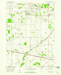
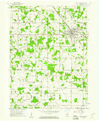
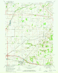
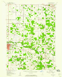 1957 Knox East1958 Print · USGSStarke County near KNOX and Grovertown is seen here in the mid-1950s, defined by its river-fed drainage and crossing rail lines. Genealogists can trace family landmarks like Crown Hill Cemetery, Eagle Creek Church, and Swartzell Cemetery.
 - 1957 Map of Knox West, 1959 Print
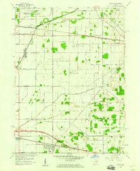
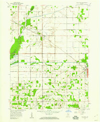 1957 Knox West1959 Print · USGSStarke County in the late fifties shows a landscape shaped by reclaimed marshlands and heavy rail traffic. Genealogists and historians can trace family locations near Knox, Toto, and Hepner Cem, or follow the routes of the New York Central Railroad.
 - 1958 Map of La Crosse, 1959 Print
 1958 La Crosse1959 Print · USGSLa Crosse was a bustling rail hub in the late fifties, where four major lines intersected amidst the reclaimed marshlands. Genealogists and rail historians can trace the paths of the Monon Railroad and Erie Railroad through early settlements like Clanricarde and Wilders.2 unique versions available
 - 1958 Map of Donaldson, 1959 Print
 1958 Donaldson1959 Print · USGSMarshall County in the late fifties was a landscape of fertile farmland and quiet rail stops like Burr Oak and Donaldson. Researchers can trace the grounds of the Convent Ancilla Domini or locate family plots at McElrath Cem.
 - 1958 Map of Kingsford Heights, 1960 Print
 1958 Kingsford Heights1960 Print · USGSThe military-industrial landscape of Northern Indiana is on full display here in the late fifties. Researchers can trace the sprawling Kingsbury Ordnance Plant and local landmarks like Tracy Cem and the Township High Sch.
 - 1958 Map of Hamlet, 1960 Print
 1958 Hamlet1960 Print · USGSRailroad hubs and reclaimed marshlands define this part of Starke County in the late fifties. Genealogists and local historians can trace the intricate network of family-named drainage lines like Amy Kelley Ditch and rail stops at Hamlet and Grovertown.
 - 1958 Map of Walkerton, 1960 Print
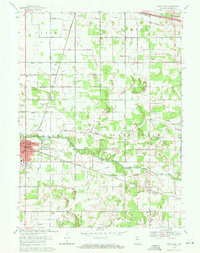
 1958 Walkerton1960 Print · USGSWalkerton was a bustling rail hub in the late fifties where three major lines intersected amidst the fertile northern Indiana plains. Genealogists and local historians can trace family ties at Barber Cem, identify the location of the Township Sch, or explore the mid-century layout of Koontz Lake and Tyner.
 - 1959 Map of English Lake, 1961 Print
 1959 English Lake1961 Print · USGSLa Porte and Starke Counties are seen here during the late 1950s, where a complex network of ditches and arms drains the marshy prairie for agriculture. Researchers can trace the tracks of the Chesapeake and Ohio Railroad and locate St Martins Cem near English Lake.2 unique versions available
 - 1959 Map of North Judson, 1961 Print
 1959 North Judson1961 Print · USGSNorth Judson was a powerhouse railroad junction in the late 1950s, where four major lines met amidst a heavily ditched agricultural landscape. Genealogists and rail historians can trace the Pennsylvania RR corridor, locate the Blue Sea Community Building, or find family ties at St Thomas Cem and Highland Cem.2 unique versions available
 - 1959 Map of San Pierre, 1961 Print
 1959 San Pierre1961 Print · USGSNorthwest Indiana in the late fifties is defined by managed wetlands and the intersection of major rail lines. Genealogists and historians can trace the rural communities of San Pierre and Tefft, locating the All Saints Cem & Cem and the Township Sch.2 unique versions available
 - 1962 Map of Denham, 1964 Print
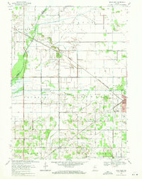
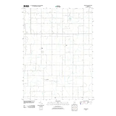
 1962 Denham1964 Print · USGSStarke and Pulaski counties are shown in the early sixties as a bustling crossroads for four major railroads. Genealogists and rail historians can trace the Erie-Lackawanna and Pennsylvania lines near Denham and the Center Cem.
 - 1962 Map of Bass Lake, 1964 Print
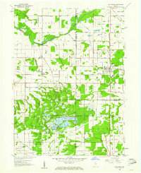
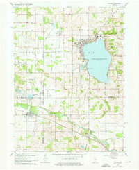
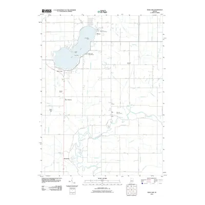
 1962 Bass Lake1964 Print · USGSStarke and Pulaski Counties are shown in the early sixties as the region balanced lakeside recreation with its rail-and-river economy. Researchers can locate family landmarks like the Township Sch, Hartz Cem, and the old rail siding at Bass Station.2 unique versions available
 - 1962 Map of Culver, 1964 Print
 1962 Culver1964 Print · USGSThe Lake Maxinkuckee region in the early sixties is dominated by the prestigious Culver Military Academy and the busy riverfront village of Monterey. Researchers can trace the Old Indian Treaty Boundary and locate family names at North Union Cem and Masonic Cem.3 unique versions available
 - 1969 Map of Kingsford Heights, 1971 Print
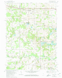
 1969 Kingsford Heights1971 Print · USGSLaPorte County at the close of the 1960s shows a landscape of engineered farmland and growing crossroads. Researchers can trace family sites near Township Cem, the unique street plan of Kingsford Heights, and the rail lines of the Penn Central.2 unique versions available
 - 1969 Map of Knox East, 1971 Print
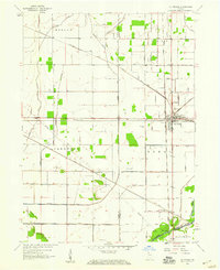
 1969 Knox East1971 Print · USGSStarke County is captured in the late sixties as the city of Knox expands along the Yellow River. Genealogists can trace family roots through numerous landmarks like Crown Hill Cemetery, St. Mathews Church, and the rural outpost of Grovertown.2 unique versions available
 - 1969 Map of Knox West, 1971 Print
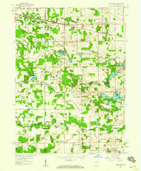
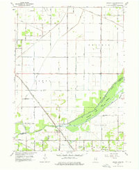
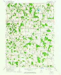
 1969 Knox West1971 Print · USGSStarke County at the end of the 1960s is a landscape of extensive drainage systems and railroad junctions. Trace the rural history of Brems and Knox, or locate local landmarks like Round Lake Ch, Hepner Cem, and the Starke County Airport.2 unique versions available
 - 1969 Map of Hamlet, 1971 Print
 1969 Hamlet1971 Print · USGSStarke and La Porte counties are captured here in the late sixties as the rail-centered economy of Hamlet remained the focal point of the local landscape. Genealogists and researchers can trace the Penn Central lines, the historic Yellowstone Trail, and landmarks like the Township Sch and Grovertown.2 unique versions available
 - 1972 Map of Donaldson, 1974 Print
 1972 Donaldson1974 Print · USGSThe rural borderlands of Marshall County are captured here in the early 1970s, showing a landscape shaped by rail lines and religious institutions. You can trace the Penn Central tracks through Donaldson or locate local landmarks like Ancilla Domini College and Burr Oak Cem.
 - 1972 Map of Walkerton, 1974 Print
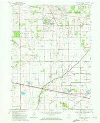
 1972 Walkerton1974 Print · USGSIn the early 1970s, the area around Walkerton was a busy rail crossroads for three major lines. Researchers can trace the path of the Baltimore and Ohio railroad through Teegarden or locate family sites near Glenn High Sch and Koontz Lake.
 - 1984 Map of Knox, 1985 Print
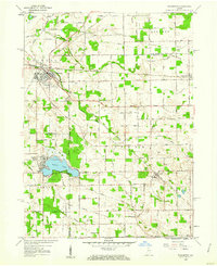
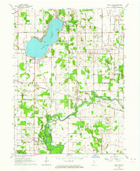
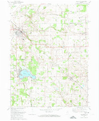
 1984 Knox1985 Print · USGSNorthern Indiana's glacial lake country is captured in the mid-eighties, showing a landscape defined by the Kankakee River and major rail lines. Genealogists and historians can trace family ties through lakefront settlements like Lake Maxinkuckee and Bass Lake or the Old Indian Treaty Boundary.2 unique versions available
 - 2010 Map of Kingsford Heights, 2010 Print
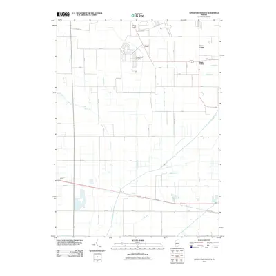 2010 Kingsford Heights2010 Print · USGSCovers Starke County, including Kingsford Heights, Union Center, and other nearby areas
 - 2010 Map of Denham, 2010 Print
 2010 Denham2010 Print · USGSCovers Starke County, including Aldine, Denham, and other nearby areas
 - 2010 Map of Bass Lake, 2010 Print
 2010 Bass Lake2010 Print · USGSCovers Starke County, including Beardstown, Ora, and other nearby areas
Showing maps 1-25 of 87
Top cities of Starke County
Frequently asked questions
- What are the different types of historical maps available for Starke County?
- What is the oldest map of Starke County?
- Where can I purchase historical maps of Starke County for my home or office?
- Where can I download high-res historical maps of Starke County?
- Are there historical topographic maps available for Starke County?
- Is there historical aerial imagery available for Starke County?
- Where are historical maps of Starke County sourced from?