1960s Maps of Starke County, Indiana
Explore 7 historic maps of Starke County from the 1960s. These maps offer a rare glimpse into what life looked like during the 1960s — showing old roads, neighborhoods, homes, and landmarks that have changed or disappeared over time.
Whether you're researching your family's past, planning a metal detecting trip, or studying how Starke County's landscape evolved across the 1960s, these high-resolution maps are a powerful tool for exploring the history of this region.
- Focus on a specific era: All maps on this page are from the 1960s, giving you a focused view of this time period.
- See what’s changed: Compare century-old streets, trails, and buildings to today's modern landscape using overlays and satellite layers.
- Research with precision: Use these maps for genealogy, historical research, land use analysis, or educational projects.
- View, download, or print: Maps are fully viewable online in high resolution, and can be downloaded or printed for your own records.
Start exploring Starke County's history through authentic maps from the 1960s. This is your window into the past.
Starke County, IN maps
(7)- 1962 Map of Denham, 1964 Print
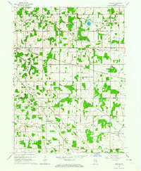 1962 Denham1964 Print · USGSStarke and Pulaski counties are shown in the early sixties as a bustling crossroads for four major railroads. Genealogists and rail historians can trace the Erie-Lackawanna and Pennsylvania lines near Denham and the Center Cem.
 - 1962 Map of Bass Lake, 1964 Print
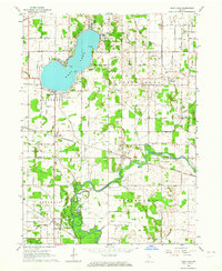 1962 Bass Lake1964 Print · USGSStarke and Pulaski Counties are shown in the early sixties as the region balanced lakeside recreation with its rail-and-river economy. Researchers can locate family landmarks like the Township Sch, Hartz Cem, and the old rail siding at Bass Station.2 unique versions available
 - 1962 Map of Culver, 1964 Print
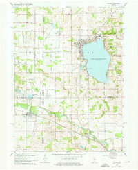 1962 Culver1964 Print · USGSThe Lake Maxinkuckee region in the early sixties is dominated by the prestigious Culver Military Academy and the busy riverfront village of Monterey. Researchers can trace the Old Indian Treaty Boundary and locate family names at North Union Cem and Masonic Cem.3 unique versions available
 - 1969 Map of Kingsford Heights, 1971 Print
 1969 Kingsford Heights1971 Print · USGSLaPorte County at the close of the 1960s shows a landscape of engineered farmland and growing crossroads. Researchers can trace family sites near Township Cem, the unique street plan of Kingsford Heights, and the rail lines of the Penn Central.2 unique versions available
 - 1969 Map of Knox East, 1971 Print
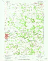 1969 Knox East1971 Print · USGSStarke County is captured in the late sixties as the city of Knox expands along the Yellow River. Genealogists can trace family roots through numerous landmarks like Crown Hill Cemetery, St. Mathews Church, and the rural outpost of Grovertown.2 unique versions available
 - 1969 Map of Knox West, 1971 Print
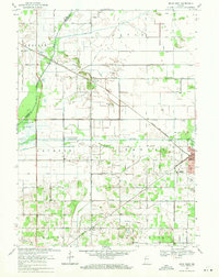 1969 Knox West1971 Print · USGSStarke County at the end of the 1960s is a landscape of extensive drainage systems and railroad junctions. Trace the rural history of Brems and Knox, or locate local landmarks like Round Lake Ch, Hepner Cem, and the Starke County Airport.2 unique versions available
 - 1969 Map of Hamlet, 1971 Print
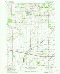
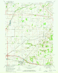 1969 Hamlet1971 Print · USGSStarke and La Porte counties are captured here in the late sixties as the rail-centered economy of Hamlet remained the focal point of the local landscape. Genealogists and researchers can trace the Penn Central lines, the historic Yellowstone Trail, and landmarks like the Township Sch and Grovertown.2 unique versions available
End of results
Showing maps 1-7 of 7
Top cities of Starke County
Frequently asked questions
- What are the different types of historical maps available for Starke County?
- What is the oldest map of Starke County?
- Where can I purchase historical maps of Starke County for my home or office?
- Where can I download high-res historical maps of Starke County?
- Are there historical topographic maps available for Starke County?
- Is there historical aerial imagery available for Starke County?
- Where are historical maps of Starke County sourced from?