1990s Maps of Flint, Indiana
Explore 1 historic maps of Flint from the 1990s. These maps offer a rare glimpse into what life looked like during the 1990s — showing old roads, neighborhoods, homes, and landmarks that have changed or disappeared over time.
Whether you're researching your family's past, planning a metal detecting trip, or studying how Flint's landscape evolved across the 1990s, these high-resolution maps are a powerful tool for exploring the history of this region.
- Focus on a specific era: All maps on this page are from the 1990s, giving you a focused view of this time period.
- See what’s changed: Compare century-old streets, trails, and buildings to today's modern landscape using overlays and satellite layers.
- Research with precision: Use these maps for genealogy, historical research, land use analysis, or educational projects.
- View, download, or print: Maps are fully viewable online in high resolution, and can be downloaded or printed for your own records.
Start exploring Flint's history through authentic maps from the 1990s. This is your window into the past.
Flint, IN maps
(1)- 1992 Map of Orland, 1993 Print
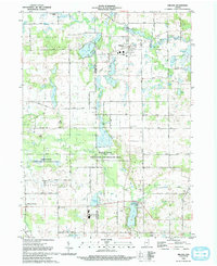 1992 Orland1993 Print · USGSSteuben and LaGrange counties are captured here in the early nineties, showing a landscape of glacial lakes and river conservation areas. Researchers can locate local landmarks like the Fawn River Fish Hatchery, Mill Grove Cem, and Charity Ch.
End of results
Showing maps 1-1 of 1
Top cities near Flint
- Kendallville historical maps
- Angola historical maps
- Jamestown historical maps
- Bronson historical maps
- Waterloo historical maps
- Rome City historical maps
See more
Frequently asked questions
- What are the different types of historical maps available for Flint?
- What is the oldest map of Flint?
- Where can I purchase historical maps of Flint for my home or office?
- Where can I download high-res historical maps of Flint?
- Are there historical topographic maps available for Flint?
- Is there historical aerial imagery available for Flint?
- Where are historical maps of Flint sourced from?