Old Maps of Steuben County, Indiana
Explore 98 old maps of Steuben County, spanning from 1939 to today. These high-resolution historic maps reveal how streets, neighborhoods, landmarks, and natural features evolved over time — perfect for genealogy, metal detecting, research, and local history exploration.
What you can do with these maps:
- See how Steuben County changed over time: Compare historical maps to modern-day views to trace roads, homesites, rail lines & more.
- View detailed metadata: Each map includes creators, publishers, year, scale, and archive source.
- Overlay maps with satellite & LiDAR: Visualize the past alongside modern tools to explore terrain & human change.
- Trusted historical sources: Maps sourced from the USGS, Library of Congress, and other archives.
- Access maps your way: View online, download high-res files, or order prints for personal or research use.
Start exploring old maps of Steuben County to uncover forgotten places, hidden landmarks, and the deep history beneath your feet.
Steuben County, IN maps
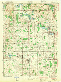
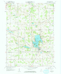
(98)- 1939 Map of Hamilton
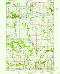
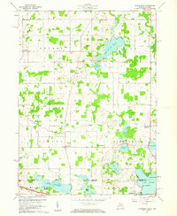
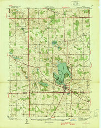 1939 Hamilton1939 Print · USGSSteuben and De Kalb counties are captured here in the late 1930s, documenting a landscape defined by glacial lakes and established farming townships. Researchers can trace rural life through the locations of Otsego Center Cem, South Scott Ch, and the shoreline developments of Hamilton Lake.
 - 1939 Map of Angola East
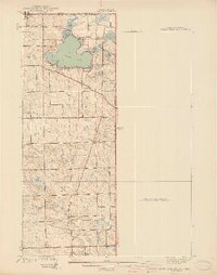
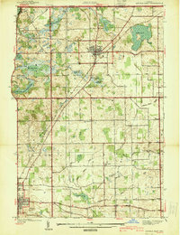 1939 Angola East1939 Print · USGSSteuben County was a landscape of glacial lakes and transition at the close of the 1930s. Researchers can trace the routes of the New York Central railroad and locate rural landmarks like Dewey Sch, Jones Chapel, and Jordan Cem.
 - 1939 Map of Clear Lake
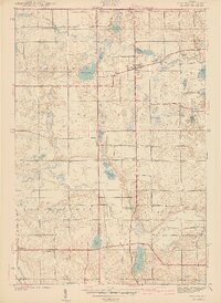
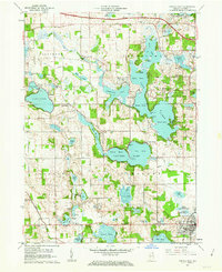
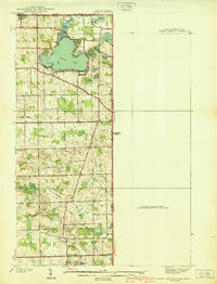 1939 Clear Lake1939 Print · USGSSteuben County was a landscape of intricate glacial lakes and quiet crossroads during the late 1930s. Researchers can trace old family lines through landmarks like Covenant Cem, the settlement at Ray, and the shoreline at Paradise Pt.2 unique versions available
 - 1940 Map of Metz
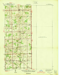 1940 Metz1940 Print · USGSThe Indiana-Ohio borderlands come into focus in the years before the war, showing a landscape of drainage ditches and family-named bridge crossings. Genealogists can trace rural life through landmarks like Metz Cem, Bethel Ch, and the small settlement of Alvarado.2 unique versions available
 - 1940 Map of Orland
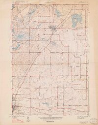
 1940 Orland1940 Print · USGSSteuben and LaGrange Counties appear at the end of the 1930s as a landscape of glacial lakes and quiet farming settlements. Genealogists can trace early homesteads near Orland, Greenlawn Cem, and the old prairie tracks of Vistula Road.2 unique versions available
 - 1940 Map of Clear Lake
 1940 Clear Lake1940 Print · USGSThe tri-state border region of Indiana, Michigan, and Ohio is captured here just before the 1940s, centered on the activity surrounding Clear Lake. Researchers can trace early school sites and family landmarks like Powers Sch, Stallman Bridge, and the Teeters Cem.2 unique versions available
 - 1941 Map of Orland
 1941 Orland1941 Print · USGSSteuben and LaGrange Counties are shown here just before the war, characterized by a landscape of glacial lakes and prairie. Trace family roots and local landmarks like Orland Fish Hatchery, Greenlawn Cem, and Greenfield Mills.2 unique versions available
 - 1941 Map of Angola West
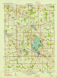
 1941 Angola West1941 Print · USGSSteuben County is a dense network of glacial lakes and early parklands at the start of the 1940s. Genealogists and local historians can trace family-named landmarks and rural outposts like the County Farm, Nevada Mills, and Lake Gage Cem.2 unique versions available
 - 1942 Map of Ashley
 1942 Ashley1942 Print · USGSNortheastern Indiana's lake country is captured in the early 1940s, showing the vital rail junction where the WABASH and Central York New lines intersect. Genealogists can trace family roots at Hollister Cem, St Johns Ch, and the settlements of Ashley and Steubenville.2 unique versions available
 - 1942 Map of Angola West
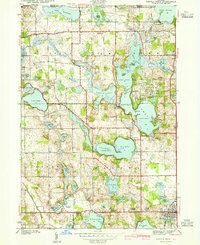
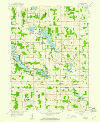
 1942 Angola West1942 Print · USGSSteuben County was a bustling hub of lakefront living and rural industry in the early 1940s. Genealogists and researchers can trace family landmarks like the Jamestown Cemetery, find the location of the County Farm, or explore the original layout of the Potawatomi Inn.
 - 1942 Map of Stroh
 1942 Stroh1942 Print · USGSNortheast Indiana’s lake country is captured here in the early 1940s, showing a landscape of small farming hamlets and lakeside landings. Researchers can trace family roots at Reed Cem or locate old community hubs like Salem Center and Helmer.2 unique versions available
 - 1947 Map of Angola East
 1947 Angola East1947 Print · USGSSteuben County was a landscape of glacial lakes and rural rail lines in the years before the interstate arrived. You can trace the New York Central route through Fremont or locate local landmarks like Jones Chapel and Scott Center Sch.2 unique versions available
 - 1948 Map of Hamilton
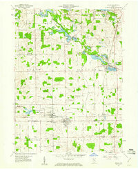
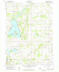
 1948 Hamilton1948 Print · USGSNortheastern Indiana's glaciated landscape is revealed here in the late 1940s, centered on the growing community of Hamilton. Genealogists can trace early homesteads and landmarks like Otsego Center Cem, the Wabash rail line, and South Scott Ch.2 unique versions available
 - 1953 Map of Fort Wayne, 1963 Print
 1953 Fort Wayne1963 Print · USGSNortheast Indiana and its neighboring borderlands in Michigan and Ohio appear here during a peak era of rail and road expansion. Researchers can trace the massive rail networks of the Nickel Plate Road and Wabash or locate lakeside landmarks like Lake Wawasee and Clear Lake.4 unique versions available
 - 1956 Map of Fort Wayne
 1956 Fort Wayne1956 Print · USGSThe tri-state borderlands of Indiana, Michigan, and Ohio are captured here in the mid-fifties, centered on the growing industrial hub of Fort Wayne. Researchers can trace the heavy rail lines of the New York Central and Pennsylvania alongside prominent water features like Lake Wawasee and the Maumee River.2 unique versions available
 - 1959 Map of Stroh, 1960 Print
 1959 Stroh1960 Print · USGSNortheast Indiana at the end of the fifties reveals a landscape defined by glacial waters where four counties meet. Genealogists and local historians can locate lakeside communities like Shady Nook and family-centered landmarks such as Weston Chapel Cem and Salem Center Sch.2 unique versions available
 - 1959 Map of Hamilton, 1961 Print
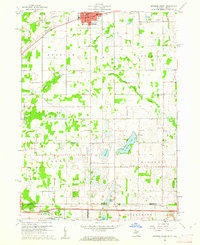
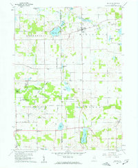
 1959 Hamilton1961 Print · USGSNortheast Indiana’s lake country is captured here during the late fifties, showing a landscape defined by glacial waters and rural townships. Researchers can trace family history through sites like Teegardin Cem, South Scott Ch, and the many parks lining Hamilton Lake.2 unique versions available
 - 1959 Map of Ashley, 1961 Print
 1959 Ashley1961 Print · USGSSteuben and DeKalb counties come together in this late 1950s survey of the lake-studded landscape around the town of Ashley. Genealogists and local historians can trace rural family landmarks like Matson Cem, Barker Ch, and the small settlement of Steubenville.3 unique versions available
 - 1960 Map of Bronson South, 1961 Print
 1960 Bronson South1961 Print · USGSThe Michigan-Indiana borderlands are captured here in the early sixties, showing the rural landscape between the railroad at Bronson and the Indiana Toll Road. Researchers can locate family landmarks like St Marys Cem, Greenfield Mills, and Hickory Corners Sch.2 unique versions available
 - 1960 Map of Camden, 1961 Print
 1960 Camden1961 Print · USGSHillsdale County and the tri-state border region are captured here in the early sixties as the rail-and-river economy of southern Michigan flourished. Researchers can trace family sites like Maple Lawn Cem or follow the New York Central through Montgomery.2 unique versions available
 - 1960 Map of Kinderhook, 1961 Print
 1960 Kinderhook1961 Print · USGSThe Michigan-Indiana state line comes alive in the early sixties, showing the rural communities of Kinderhook and East Gilead amid a landscape of glacial lakes. Researchers can trace family roots at Knauss Cem or Ovid Cem and locate vanished landmarks like Snow Prairie Sch.
 - 1960 Map of California, 1962 Print
 1960 California1962 Print · USGSBranch County, Michigan, and Steuben County, Indiana, meet at the state line in this 1960 survey. Researchers can trace rural lineages through numerous cemeteries like Wilson Cem and Lester Cem or locate the old Amish Sch and Stokes Chapel.2 unique versions available
 - 1960 Map of Orland, 1962 Print
 1960 Orland1962 Print · USGSThe Indiana lake country at the turn of the sixties reveals a landscape shaped by conservation and rural community life. Genealogists and historians can trace family locations through Greenlawn Cem, East Springfield Ch, and the settlement of Orland.2 unique versions available
 - 1960 Map of Angola East, 1962 Print
 1960 Angola East1962 Print · USGSSteuben County during the early sixties shows a landscape transitioning between traditional farming and modern infrastructure. Genealogists and local historians can locate family landmarks like Jones Chapel, Lakeside Cem, and the Scott Center Sch.3 unique versions available
 - 1960 Map of Angola West, 1963 Print
 1960 Angola West1963 Print · USGSSteuben County is a network of mid-century resorts and rural settlements at the height of the post-war vacation era. Researchers can locate vanished names and civic landmarks from Nevada Mills to Tri-State College and the Potawatomi Inn.3 unique versions available
Showing maps 1-25 of 98
Top cities of Steuben County
- Angola historical maps
- Jamestown historical maps
- Fremont historical maps
- York historical maps
- Hudson historical maps
- Clear Lake historical maps
See more
Frequently asked questions
- What are the different types of historical maps available for Steuben County?
- What is the oldest map of Steuben County?
- Where can I purchase historical maps of Steuben County for my home or office?
- Where can I download high-res historical maps of Steuben County?
- Are there historical topographic maps available for Steuben County?
- Is there historical aerial imagery available for Steuben County?
- Where are historical maps of Steuben County sourced from?