1930s Maps of Steuben County, Indiana
Explore 3 historic maps of Steuben County from the 1930s. These maps offer a rare glimpse into what life looked like during the 1930s — showing old roads, neighborhoods, homes, and landmarks that have changed or disappeared over time.
Whether you're researching your family's past, planning a metal detecting trip, or studying how Steuben County's landscape evolved across the 1930s, these high-resolution maps are a powerful tool for exploring the history of this region.
- Focus on a specific era: All maps on this page are from the 1930s, giving you a focused view of this time period.
- See what’s changed: Compare century-old streets, trails, and buildings to today's modern landscape using overlays and satellite layers.
- Research with precision: Use these maps for genealogy, historical research, land use analysis, or educational projects.
- View, download, or print: Maps are fully viewable online in high resolution, and can be downloaded or printed for your own records.
Start exploring Steuben County's history through authentic maps from the 1930s. This is your window into the past.
Steuben County, IN maps
(3)- 1939 Map of Hamilton
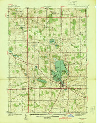 1939 Hamilton1939 Print · USGSSteuben and De Kalb counties are captured here in the late 1930s, documenting a landscape defined by glacial lakes and established farming townships. Researchers can trace rural life through the locations of Otsego Center Cem, South Scott Ch, and the shoreline developments of Hamilton Lake.
 - 1939 Map of Angola East
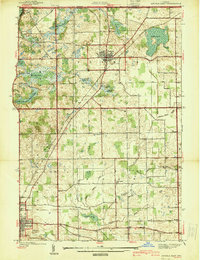 1939 Angola East1939 Print · USGSSteuben County was a landscape of glacial lakes and transition at the close of the 1930s. Researchers can trace the routes of the New York Central railroad and locate rural landmarks like Dewey Sch, Jones Chapel, and Jordan Cem.
 - 1939 Map of Clear Lake
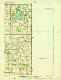 1939 Clear Lake1939 Print · USGSSteuben County was a landscape of intricate glacial lakes and quiet crossroads during the late 1930s. Researchers can trace old family lines through landmarks like Covenant Cem, the settlement at Ray, and the shoreline at Paradise Pt.2 unique versions available
End of results
Showing maps 1-3 of 3
Top cities of Steuben County
- Angola historical maps
- Jamestown historical maps
- Fremont historical maps
- York historical maps
- Hudson historical maps
- Clear Lake historical maps
See more
Frequently asked questions
- What are the different types of historical maps available for Steuben County?
- What is the oldest map of Steuben County?
- Where can I purchase historical maps of Steuben County for my home or office?
- Where can I download high-res historical maps of Steuben County?
- Are there historical topographic maps available for Steuben County?
- Is there historical aerial imagery available for Steuben County?
- Where are historical maps of Steuben County sourced from?