1940s Maps of Steuben County, Indiana
Explore 10 historic maps of Steuben County from the 1940s. These maps offer a rare glimpse into what life looked like during the 1940s — showing old roads, neighborhoods, homes, and landmarks that have changed or disappeared over time.
Whether you're researching your family's past, planning a metal detecting trip, or studying how Steuben County's landscape evolved across the 1940s, these high-resolution maps are a powerful tool for exploring the history of this region.
- Focus on a specific era: All maps on this page are from the 1940s, giving you a focused view of this time period.
- See what’s changed: Compare century-old streets, trails, and buildings to today's modern landscape using overlays and satellite layers.
- Research with precision: Use these maps for genealogy, historical research, land use analysis, or educational projects.
- View, download, or print: Maps are fully viewable online in high resolution, and can be downloaded or printed for your own records.
Start exploring Steuben County's history through authentic maps from the 1940s. This is your window into the past.
Steuben County, IN maps
(10)- 1940 Map of Metz
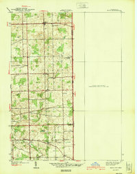 1940 Metz1940 Print · USGSThe Indiana-Ohio borderlands come into focus in the years before the war, showing a landscape of drainage ditches and family-named bridge crossings. Genealogists can trace rural life through landmarks like Metz Cem, Bethel Ch, and the small settlement of Alvarado.2 unique versions available
 - 1940 Map of Orland
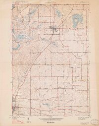
 1940 Orland1940 Print · USGSSteuben and LaGrange Counties appear at the end of the 1930s as a landscape of glacial lakes and quiet farming settlements. Genealogists can trace early homesteads near Orland, Greenlawn Cem, and the old prairie tracks of Vistula Road.2 unique versions available
 - 1940 Map of Clear Lake
 1940 Clear Lake1940 Print · USGSThe tri-state border region of Indiana, Michigan, and Ohio is captured here just before the 1940s, centered on the activity surrounding Clear Lake. Researchers can trace early school sites and family landmarks like Powers Sch, Stallman Bridge, and the Teeters Cem.2 unique versions available
 - 1941 Map of Orland
 1941 Orland1941 Print · USGSSteuben and LaGrange Counties are shown here just before the war, characterized by a landscape of glacial lakes and prairie. Trace family roots and local landmarks like Orland Fish Hatchery, Greenlawn Cem, and Greenfield Mills.2 unique versions available
 - 1941 Map of Angola West
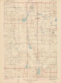
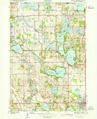 1941 Angola West1941 Print · USGSSteuben County is a dense network of glacial lakes and early parklands at the start of the 1940s. Genealogists and local historians can trace family-named landmarks and rural outposts like the County Farm, Nevada Mills, and Lake Gage Cem.2 unique versions available
 - 1942 Map of Ashley
 1942 Ashley1942 Print · USGSNortheastern Indiana's lake country is captured in the early 1940s, showing the vital rail junction where the WABASH and Central York New lines intersect. Genealogists can trace family roots at Hollister Cem, St Johns Ch, and the settlements of Ashley and Steubenville.2 unique versions available
 - 1942 Map of Angola West
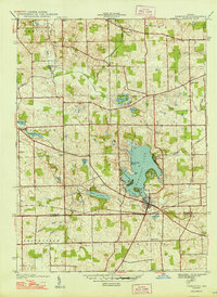
 1942 Angola West1942 Print · USGSSteuben County was a bustling hub of lakefront living and rural industry in the early 1940s. Genealogists and researchers can trace family landmarks like the Jamestown Cemetery, find the location of the County Farm, or explore the original layout of the Potawatomi Inn.
 - 1942 Map of Stroh
 1942 Stroh1942 Print · USGSNortheast Indiana’s lake country is captured here in the early 1940s, showing a landscape of small farming hamlets and lakeside landings. Researchers can trace family roots at Reed Cem or locate old community hubs like Salem Center and Helmer.2 unique versions available
 - 1947 Map of Angola East
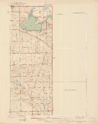
 1947 Angola East1947 Print · USGSSteuben County was a landscape of glacial lakes and rural rail lines in the years before the interstate arrived. You can trace the New York Central route through Fremont or locate local landmarks like Jones Chapel and Scott Center Sch.2 unique versions available
 - 1948 Map of Hamilton
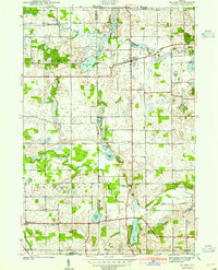
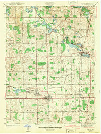
 1948 Hamilton1948 Print · USGSNortheastern Indiana's glaciated landscape is revealed here in the late 1940s, centered on the growing community of Hamilton. Genealogists can trace early homesteads and landmarks like Otsego Center Cem, the Wabash rail line, and South Scott Ch.2 unique versions available
End of results
Showing maps 1-10 of 10
Top cities of Steuben County
- Angola historical maps
- Jamestown historical maps
- Fremont historical maps
- York historical maps
- Hudson historical maps
- Clear Lake historical maps
See more
Frequently asked questions
- What are the different types of historical maps available for Steuben County?
- What is the oldest map of Steuben County?
- Where can I purchase historical maps of Steuben County for my home or office?
- Where can I download high-res historical maps of Steuben County?
- Are there historical topographic maps available for Steuben County?
- Is there historical aerial imagery available for Steuben County?
- Where are historical maps of Steuben County sourced from?