1900s (20th Century) Maps of Universal, Indiana
Explore 9 historic maps of Universal from the 1900s (20th Century). These maps offer a rare glimpse into what life looked like during the 1900s — showing old roads, neighborhoods, homes, and landmarks that have changed or disappeared over time.
Whether you're researching your family's past, planning a metal detecting trip, or studying how Universal's landscape evolved across the 1900s, these high-resolution maps are a powerful tool for exploring the history of this region.
- Focus on a specific era: All maps on this page are from the 1900s, giving you a focused view of this time period.
- See what’s changed: Compare century-old streets, trails, and buildings to today's modern landscape using overlays and satellite layers.
- Research with precision: Use these maps for genealogy, historical research, land use analysis, or educational projects.
- View, download, or print: Maps are fully viewable online in high resolution, and can be downloaded or printed for your own records.
Start exploring Universal's history through authentic maps from the 1900s. This is your window into the past.
Universal, IN maps
(9)- 1950 Map of New Goshen, 1952 Print
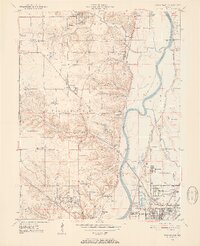 1950 New Goshen1952 Print · USGSVigo County in the early fifties is captured here as a landscape of river-side industry and emerging suburbs north of Terre Haute. Researchers can locate the historic St Mary-of-the-Woods College or trace the path of the Erie Canal (Abandoned) past Shepardsville and Tecumseh.3 unique versions available
 - 1951 Map of Clinton, 1953 Print
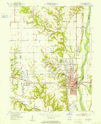 1951 Clinton1953 Print · USGSClinton and the Wabash River valley are captured in the early fifties, a time when coal extraction and rail transport defined the local economy. Researchers can trace family landmarks and schools like Higgins Mathews Sch and Glendale Sch, or locate the many Strip Mine sites that once dotted the landscape near Centenary and Klondyke.2 unique versions available
 - 1953 Map of Indianapolis, 1965 Print
 1953 Indianapolis1965 Print · USGSCentral Indiana and the Illinois borderlands are captured in the mid-sixties, showing the growth of Indianapolis and its industrial rail corridors. Genealogists and historians can trace the development of outlying towns like Zionsville or Beech Grove and find landmarks such as Atterbury AAF and Turkey Run State Park.4 unique versions available
 - 1956 Map of Indianapolis
 1956 Indianapolis1956 Print · USGSCentral Indiana in the mid-fifties is captured during a period of industrial growth and military presence. Genealogists and historians can trace the rail networks of the New York Central or locate regional landmarks like Fort Benjamin Harrison and Camp Atterbury.
 - 1957 Map of Indianapolis
 1957 Indianapolis1957 Print · USGSCentral Indiana in the mid-fifties is captured here as a crossroads of major rail lines and nascent federal highways. Genealogists and historians can trace family-named ridges like Poplar Ridge or locate strategic sites like Camp Atterbury and Speedway.2 unique versions available
 - 1962 Map of Indianapolis
 1962 Indianapolis1962 Print · USGSCentral Indiana and the Illinois borderlands are captured here in the early sixties, showing the region's dense rail networks and growing urban centers. Genealogists and historians can locate family-named landmarks and institutions like Crown Hill Cem, Indiana University, and the Indianapolis Motor Speedway.
 - 1963 Map of New Goshen, 1965 Print
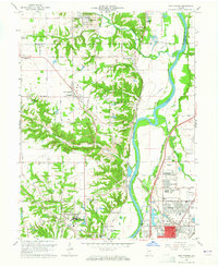 1963 New Goshen1965 Print · USGSThe West Central Indiana borderlands come into focus in the early sixties as industrial coal mining and river transport converge. Researchers can trace the historic Erie Canal alignment or locate family roots at St Mary-of-the-Woods College and Barbour Cem.4 unique versions available
 - 1978 Map of Clinton, 1979 Print
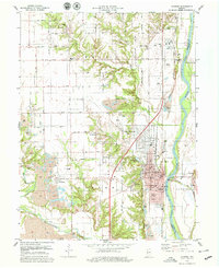 1978 Clinton1979 Print · USGSVermillion County life in the late seventies is captured here, centered on the riverfront bustle of Clinton and the extensive coal mines to the west. Researchers can trace family roots through numerous sites like Ernie Pyle Sch, Centenary, and the historic Covered Bridge.2 unique versions available
 - 1986 Map of Paris
 1986 Paris1986 Print · USGSThe Illinois-Indiana borderlands thrive in the mid-1980s as a hub of river-side industry and fertile farmland. Genealogists and historians can trace rail-centered settlements like Chrisman and Metcalf, or locate family sites at the Quaker Cem and Bethel Ch.2 unique versions available
End of results
Showing maps 1-9 of 9
Top cities near Universal
- Terre Haute historical maps
- Paris historical maps
- Clinton historical maps
- Marshall historical maps
- Rockville historical maps
- West Terre Haute historical maps
See more
Frequently asked questions
- What are the different types of historical maps available for Universal?
- What is the oldest map of Universal?
- Where can I purchase historical maps of Universal for my home or office?
- Where can I download high-res historical maps of Universal?
- Are there historical topographic maps available for Universal?
- Is there historical aerial imagery available for Universal?
- Where are historical maps of Universal sourced from?