1980s Maps of Nanito, Iowa
Explore 2 historic maps of Nanito from the 1980s. These maps offer a rare glimpse into what life looked like during the 1980s — showing old roads, neighborhoods, homes, and landmarks that have changed or disappeared over time.
Whether you're researching your family's past, planning a metal detecting trip, or studying how Nanito's landscape evolved across the 1980s, these high-resolution maps are a powerful tool for exploring the history of this region.
- Focus on a specific era: All maps on this page are from the 1980s, giving you a focused view of this time period.
- See what’s changed: Compare century-old streets, trails, and buildings to today's modern landscape using overlays and satellite layers.
- Research with precision: Use these maps for genealogy, historical research, land use analysis, or educational projects.
- View, download, or print: Maps are fully viewable online in high resolution, and can be downloaded or printed for your own records.
Start exploring Nanito's history through authentic maps from the 1980s. This is your window into the past.
Nanito, IA maps
(2)- 1983 Map of Arbor Hill, 1984 Print
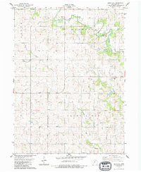 1983 Arbor Hill1984 Print · USGSAdair County farm country is documented here in the early eighties as a network of quiet townships and winding prairie rivers. Genealogists can trace family landmarks and burial sites like Roberts Cem, the settlement at Hebron, and the rural Bethel Ch.
 - 1985 Map of Creston
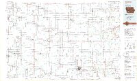 1985 Creston1985 Print · USGSSouthwest Iowa in the mid-eighties shows a landscape of established farm towns and growing regional hubs connected by vital rail lines. Genealogists and local historians can trace landmarks like Graceland Cem, the Southwestern Community College campus, and the Burlington Northern railroad route.
End of results
Showing maps 1-2 of 2
Top cities near Nanito
- Greenfield historical maps
- Stuart historical maps
- Earlham historical maps
- Dexter historical maps
- Casey historical maps
- Orient historical maps
See more
Frequently asked questions
- What are the different types of historical maps available for Nanito?
- What is the oldest map of Nanito?
- Where can I purchase historical maps of Nanito for my home or office?
- Where can I download high-res historical maps of Nanito?
- Are there historical topographic maps available for Nanito?
- Is there historical aerial imagery available for Nanito?
- Where are historical maps of Nanito sourced from?