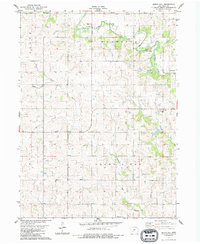
1983 Map of Arbor Hill
USGS Topo · Published 1984About this map
Arbor Hill sits at the northern edge of this Adair County landscape, where the Middle River winds through the townships of Harrison and Grove. This early 1980s topographic record shows a deeply agricultural region defined by its waterway network, including the southward-flowing Thompson River and the headwaters of Battle Creek. The rural settlement pattern is anchored by small communities such as Stanzel and Hebron, each maintaining a distinct identity through local institutions like the Bethel Ch and the Townhall located near the river crossing. For genealogists and local historians, the map serves as a precise guide to cemetery locations, including Roberts Cem, Grand River Center Cem, and Hebron Cem. The inclusion of the Middle River County Forest highlights a significant pocket of preserved timberland amidst the predominantly cleared farmland of southwestern Iowa.
Find a feature on this map
20 named features on this map. Tap any name to fly to it.
Don’t see what you’re looking for? This feature index may not catch every label — zoom into the map to look around manually.
Map Details
Editions of this 1983 Arbor Hill Map
This is the sole edition of this map. No revisions or reprints were ever made.
Other maps of this area

1951 · Afton
USGS Topo · 1:62,500

1952 · Winterset
USGS Topo · 1:62,500

1954 · Greenfield
USGS Topo · 1:62,500

1954 · Omaha
USGS Topo · 1:250,000

1957 · Omaha
USGS Topo · 1:250,000

1958 · Omaha
USGS Topo · 1:250,000

1981 · Zion
USGS Topo · 1:24,000
1981 · Orient
USGS Topo · 1:24,000
1983 · Rosserdale
USGS Topo · 1:24,000
1983 · Earlham West
USGS Topo · 1:24,000