
1957 Map of Omaha
USGS Topo · Published 1957About this map
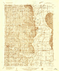
The Missouri River corridor serves as the primary artery for this mid-century landscape, anchoring the major hubs of Omaha and Council Bluffs. This Army Map Service compilation from the 1950s illustrates a region defined by its intensive agricultural grid and vital transportation links, including the Chicago Milwaukee St Paul And Pacific and Chicago And North Western railroads. To the south, Offutt Air Force Base stands as a significant military installation near the confluence of the Missouri and the Platte River.
Find a feature on this map
66 named features on this map. Tap any name to fly to it.
Don’t see what you’re looking for? This feature index may not catch every label — zoom into the map to look around manually.
Map Details
Editions of this 1957 Omaha Map
This is the sole edition of this map. No revisions or reprints were ever made.
Other maps of this area

1893 · Omaha
USGS Topo · 1:62,500

1893 · Fremont
USGS Topo · 1:125,000

1896 · Fremont
USGS Topo · 1:125,000

1903 · Weeping Water
USGS Topo · 1:125,000

1908 · Waukee
USGS Topo · 1:62,500

1911 · Madrid
USGS Topo · 1:62,500

1914 · Madrid
USGS Topo · 1:62,500

1916 · Boone
USGS Topo · 1:62,500

1929 · Weeping Water
USGS Topo · 1:125,000
1935 · Nehawka
USGS Topo · 1:48,000