
Loading...
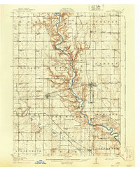
Loading map...1911 Map of Madrid
USGS Topo · Published 1958About this map
The Des Moines River carves a deep, winding valley through the center of this landscape, separating the townships of Worth and Cass from Colfax and Garden. Surveyed in 1911, the map documents a dense network of rural schoolhouses, such as Rosebud School and Independence School, indicating a well-populated agricultural interior before the mid-century consolidation of rural districts.
Find a feature on this map
80 named features on this map. Tap any name to fly to it.
Don’t see what you’re looking for? This feature index may not catch every label — zoom into the map to look around manually.
Map Details
Date Portrayed1911
Date Published1958
PublisherU.S. Geological Survey
Map TypeTopographic
Scale1:62,500
Physical Dimensions17 x 20.9 inches
Editions of this 1911 Madrid Map
This is the sole edition of this map. No revisions or reprints were ever made.
Historical Maps of Johnston Through Time
Featured Locations
Source Details
SourceU.S. Geological Survey
CopyrightPublic Domain