
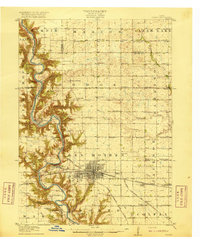
1916 Map of Boone
USGS Topo · Published 1916About this map
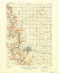
The Des Moines River carves a deep valley through the center of this terrain, its winding course flanked by dramatic bluffs and tributary ravines. This landscape at the time of the 1913-1914 survey was a complex network of rail and river industry, centered on the growing hub of Boone. The map documents a high density of rural education, with uniquely named institutions like Incline School, Coal Valley School, and Hickory Grove School serving the farming and mining communities. A fascinating social landmark, the Poor Farm, is located north of the river's bend, while the small riverside settlements of Fraser and Moingona illustrate the importance of the valley for transport and settlement. The intricate rail infrastructure is dominated by the Fort Dodge Des Moines and Southern and the Chicago and Northwestern, which cross the river and connect these isolated valley outposts to the larger regional economy.
Find a feature on this map
65 named features on this map. Tap any name to fly to it.
Don’t see what you’re looking for? This feature index may not catch every label — zoom into the map to look around manually.
Map Details
Editions of this 1916 Boone Map
3 editions found
Historical Maps of Boone Through Time
1 maps found