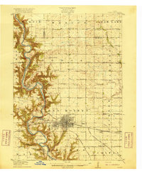
1916 Map of Boone
USGS Topo · Published 1916About this map
The Des Moines River carves a deep, winding valley through the heart of this landscape, creating a dramatic contrast between the flat upland prairies and the heavily dissected river bluffs. This 1916 edition captures the region's dense network of early 20th-century rural infrastructure, particularly the staggering number of country schoolhouses such as Incline School, Coal Valley School, and Hickory Grove School that once anchored these townships.
Find a feature on this map
66 named features on this map. Tap any name to fly to it.
Don’t see what you’re looking for? This feature index may not catch every label — zoom into the map to look around manually.
Map Details
Editions of this 1916 Boone Map
3 editions found
Other maps of this area

1911 · Madrid
USGS Topo · 1:62,500

1911 · Slater
USGS Topo · 1:62,500

1912 · Ames
USGS Topo · 1:62,500

1913 · Slater
USGS Topo · 1:62,500

1914 · Madrid
USGS Topo · 1:62,500

1914 · Ames
USGS Topo · 1:62,500

1916 · Boone
USGS Topo · 1:62,500

1923 · Lehigh
USGS Topo · 1:62,500

1950 · Perry
USGS Topo · 1:62,500

1951 · Perry
USGS Topo · 1:62,500