
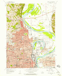
1893 Map of Omaha
USGS Topo · Published 1893About this map
The Missouri River forms the central spine of this 1893 landscape, serving as a shifting border between Nebraska and Iowa. The burgeoning street grids of Omaha and Council Bluffs dominate the southern portion of the sheet, while the river’s winding course creates a series of oxbow lakes, including Spoon Lake, Florence Lake, and Cutoff Lake. These water bodies are remnants of a dynamic river system that dictated the placement of settlements and vital rail lines.
Find a feature on this map
25 named features on this map. Tap any name to fly to it.
Don’t see what you’re looking for? This feature index may not catch every label — zoom into the map to look around manually.
Map Details
Editions of this 1893 Omaha Map
This is the sole edition of this map. No revisions or reprints were ever made.
Other maps of this area

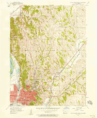
1893 · Fremont
USGS Topo · 1:125,000

1896 · Fremont
USGS Topo · 1:125,000

1954 · Omaha
USGS Topo · 1:250,000

1955 · Fremont
USGS Topo · 1:250,000
1956 · Underwood
USGS Topo · 1:24,000
1956 · Ralston
USGS Topo · 1:24,000
1956 · Mineola
USGS Topo · 1:24,000
1956 · Irvington
USGS Topo · 1:24,000
1956 · Council Bluffs North
USGS Topo · 1:24,000
1956 · Omaha North
USGS Topo · 1:24,000