1960s Maps of Fraser, Iowa
Explore 2 historic maps of Fraser from the 1960s. These maps offer a rare glimpse into what life looked like during the 1960s — showing old roads, neighborhoods, homes, and landmarks that have changed or disappeared over time.
Whether you're researching your family's past, planning a metal detecting trip, or studying how Fraser's landscape evolved across the 1960s, these high-resolution maps are a powerful tool for exploring the history of this region.
- Focus on a specific era: All maps on this page are from the 1960s, giving you a focused view of this time period.
- See what’s changed: Compare century-old streets, trails, and buildings to today's modern landscape using overlays and satellite layers.
- Research with precision: Use these maps for genealogy, historical research, land use analysis, or educational projects.
- View, download, or print: Maps are fully viewable online in high resolution, and can be downloaded or printed for your own records.
Start exploring Fraser's history through authentic maps from the 1960s. This is your window into the past.
Fraser, IA maps
(2)- 1965 Map of Fraser, 1966 Print
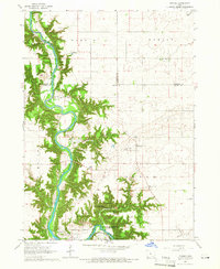 1965 Fraser1966 Print · USGSThe Des Moines River valley in the mid-1960s reveals a rural landscape transitioning toward major hydrological management. Researchers can trace ancestral locations at Hardin Cem or Mineral Ridge Cem and locate vanished landmarks near Ridgeport and Fraser.
 - 1965 Map of Boone West, 1966 Print
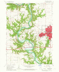 1965 Boone West1966 Print · USGSThe Des Moines River valley in the mid-1960s shows a landscape of deep ravines, active mining, and new water management. Trace local history through Moingona, Battin Chapel, and the vanished Mine Dump sites near Logansport.2 unique versions available
End of results
Showing maps 1-2 of 2
Top cities near Fraser
- Boone historical maps
- Ogden historical maps
- Dayton historical maps
- Stratford historical maps
- Lehigh historical maps
- Stanhope historical maps
See more
Frequently asked questions
- What are the different types of historical maps available for Fraser?
- What is the oldest map of Fraser?
- Where can I purchase historical maps of Fraser for my home or office?
- Where can I download high-res historical maps of Fraser?
- Are there historical topographic maps available for Fraser?
- Is there historical aerial imagery available for Fraser?
- Where are historical maps of Fraser sourced from?