1960s Maps of Cedar County, Iowa
Explore 10 historic maps of Cedar County from the 1960s. These maps offer a rare glimpse into what life looked like during the 1960s — showing old roads, neighborhoods, homes, and landmarks that have changed or disappeared over time.
Whether you're researching your family's past, planning a metal detecting trip, or studying how Cedar County's landscape evolved across the 1960s, these high-resolution maps are a powerful tool for exploring the history of this region.
- Focus on a specific era: All maps on this page are from the 1960s, giving you a focused view of this time period.
- See what’s changed: Compare century-old streets, trails, and buildings to today's modern landscape using overlays and satellite layers.
- Research with precision: Use these maps for genealogy, historical research, land use analysis, or educational projects.
- View, download, or print: Maps are fully viewable online in high resolution, and can be downloaded or printed for your own records.
Start exploring Cedar County's history through authentic maps from the 1960s. This is your window into the past.
Cedar County, IA maps
(10)- 1961 Map of Davenport
 1961 Davenport1961 Print · USGSThe Quad Cities and the eastern Iowa riverlands are captured here in the early sixties, showing the region's transition into a modern industrial and transit hub. Genealogists and historians can trace the paths of major railroads and find river landmarks like Rock Island Arsenal, Huron Island, and the Coralville Reservoir.
 - 1962 Map of Davenport
 1962 Davenport1962 Print · USGSThe Quad Cities and the Mississippi River corridor are shown at their industrial peak just before the interstate era fully transformed the region. Researchers can trace the sprawling rail networks of the Chicago Rock Island and Pacific and find landmarks like the Rock Island Arsenal and Wild Cat Den State Park.
 - 1965 Map of West Liberty, 1966 Print
 1965 West Liberty1966 Print · USGSMid-century Muscatine County is centered here on the busy rail junction of West Liberty and the surrounding prairie farmsteads. Researchers can trace family history through numerous rural landmarks like South Prairie Grange Hall, Oak Ridge Cemetery, and the settlement at Downey.
 - 1965 Map of Stanwood, 1966 Print
 1965 Stanwood1966 Print · USGSEastern Iowa's agricultural heartland is documented here during the mid-sixties, showing the rail-linked growth of Mechanicsville and Stanwood. Researchers can trace the Chicago and North Western line or locate family sites like Walnut Grove Cem and Olin Cem.
 - 1965 Map of Atalissa, 1966 Print
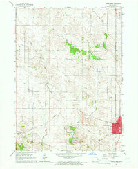
 1965 Atalissa1966 Print · USGSMuscatine and Cedar Counties are captured in the mid-1960s, showing the agricultural heartland centered on the Atalissa rail corridor. Genealogists can locate family sites like Timberlake Cem and Overman Cem near the Wiese Slough.
 - 1965 Map of Cedar Bluff, 1967 Print
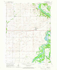
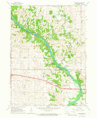
 1965 Cedar Bluff1967 Print · USGSCedar County's river valley comes to life in the mid-1960s, showing the rural landscape around Cedar Bluff and the winding Cedar River. Researchers can trace old family roots and transport history at Evergreen Cem, St Bridget Ch, and the lingering Old RR Grade.
 - 1965 Map of Mechanicsville, 1967 Print
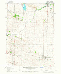
 1965 Mechanicsville1967 Print · USGSThe rural landscape of Eastern Iowa is captured in the mid-1960s, showing the intersection of three counties around the rail town of Mechanicsville. Researchers can trace old family burial sites like Andre Cem and Pioneer Cem or follow the Chicago and North Western rail line.
 - 1965 Map of Rochester, 1967 Print
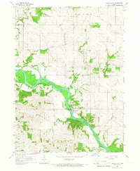
 1965 Rochester1967 Print · USGSThe Cedar River valley in the mid-sixties reveals a landscape of established river towns and quiet farming townships. Genealogists can trace family roots at Mt Zion Cem, Pee Dee Cem, and Rochester Cem, while locating landmarks like Mt Zion Ch and Rochester Park.
 - 1965 Map of Tipton West, 1967 Print
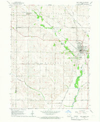
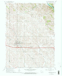
 1965 Tipton West1967 Print · USGSThe rural landscape of Cedar County in the 1960s reveals a community built on agriculture and rail. Genealogists and local historians can trace family locations through sites like Sand Hill Cem, Red Oak Ch, and the Old Railroad Grade near Buchanan.
 - 1965 Map of West Branch, 1967 Print
 1965 West Branch1967 Print · USGSEastern Iowa farmland centered on West Branch is captured here in the mid-sixties, just as modern interstate travel was reshaping the region. Genealogists and historians can trace family locations near the Hoover Birthplace National Historic Site, Scattergood Sch, and Honey Grove Cem.2 unique versions available
End of results
Showing maps 1-10 of 10
Top cities of Cedar County
- Tipton historical maps
- West Branch historical maps
- Durant historical maps
- Clarence historical maps
- Mechanicsville historical maps
- Lowden historical maps
See more
Frequently asked questions
- What are the different types of historical maps available for Cedar County?
- What is the oldest map of Cedar County?
- Where can I purchase historical maps of Cedar County for my home or office?
- Where can I download high-res historical maps of Cedar County?
- Are there historical topographic maps available for Cedar County?
- Is there historical aerial imagery available for Cedar County?
- Where are historical maps of Cedar County sourced from?