1990s Maps of Cedar County, Iowa
Explore 5 historic maps of Cedar County from the 1990s. These maps offer a rare glimpse into what life looked like during the 1990s — showing old roads, neighborhoods, homes, and landmarks that have changed or disappeared over time.
Whether you're researching your family's past, planning a metal detecting trip, or studying how Cedar County's landscape evolved across the 1990s, these high-resolution maps are a powerful tool for exploring the history of this region.
- Focus on a specific era: All maps on this page are from the 1990s, giving you a focused view of this time period.
- See what’s changed: Compare century-old streets, trails, and buildings to today's modern landscape using overlays and satellite layers.
- Research with precision: Use these maps for genealogy, historical research, land use analysis, or educational projects.
- View, download, or print: Maps are fully viewable online in high resolution, and can be downloaded or printed for your own records.
Start exploring Cedar County's history through authentic maps from the 1990s. This is your window into the past.
Cedar County, IA maps
(5)- 1991 Map of Lime City, 1992 Print
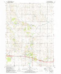 1991 Lime City1992 Print · USGSCedar County's rural townships are shown in the early nineties, centered on the small community of Lime City. Researchers can trace old family burials at Moneka Cem or Fairland Cem, alongside local landmarks like Koch Lake and several Quarry operations.
 - 1991 Map of Lowden, 1992 Print
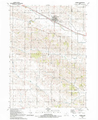 1991 Lowden1992 Print · USGSEastern Iowa farmland centered on the railroad town of Lowden is documented here just before the turn of the millennium. Researchers can trace rural family plots and community hubs like Inland Cem, Zion Ch, and the waters of Yankee Run.
 - 1991 Map of Bennett, 1992 Print
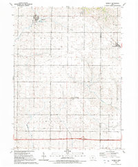 1991 Bennett1992 Print · USGSThe rural borderlands of Cedar and Scott counties are captured here in the early nineties, featuring the established town sites of Bennett and Sunbury. Genealogists and local historians can trace township boundaries across Inland and Farmington or locate landmarks like Bennett Park and New Liberty.
 - 1991 Map of Durant, 1992 Print
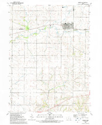 1991 Durant1992 Print · USGSEastern Iowa's borderlands near the tri-county junction of Cedar, Muscatine, and Scott are captured in the early nineties. Genealogists and local historians can trace the street grid of Durant, locate Melpine Cem, and follow the courses of Mud Creek and Big Elkhorn Creek.
 - 1991 Map of Wilton, 1992 Print
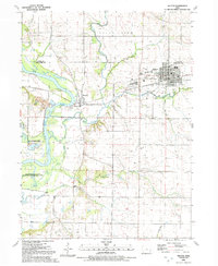 1991 Wilton1992 Print · USGSWilton and the Cedar River valley appear in the early nineties, showing a landscape defined by small towns and river floodplains. Genealogists can locate several historic burial sites like St Marys Cem and Wildsin Cem, or trace the Old Railroad Grade.
End of results
Showing maps 1-5 of 5
Top cities of Cedar County
- Tipton historical maps
- West Branch historical maps
- Durant historical maps
- Clarence historical maps
- Mechanicsville historical maps
- Lowden historical maps
See more
Frequently asked questions
- What are the different types of historical maps available for Cedar County?
- What is the oldest map of Cedar County?
- Where can I purchase historical maps of Cedar County for my home or office?
- Where can I download high-res historical maps of Cedar County?
- Are there historical topographic maps available for Cedar County?
- Is there historical aerial imagery available for Cedar County?
- Where are historical maps of Cedar County sourced from?