1970s Maps of Dougherty, Iowa
Explore 1 historic maps of Dougherty from the 1970s. These maps offer a rare glimpse into what life looked like during the 1970s — showing old roads, neighborhoods, homes, and landmarks that have changed or disappeared over time.
Whether you're researching your family's past, planning a metal detecting trip, or studying how Dougherty's landscape evolved across the 1970s, these high-resolution maps are a powerful tool for exploring the history of this region.
- Focus on a specific era: All maps on this page are from the 1970s, giving you a focused view of this time period.
- See what’s changed: Compare century-old streets, trails, and buildings to today's modern landscape using overlays and satellite layers.
- Research with precision: Use these maps for genealogy, historical research, land use analysis, or educational projects.
- View, download, or print: Maps are fully viewable online in high resolution, and can be downloaded or printed for your own records.
Start exploring Dougherty's history through authentic maps from the 1970s. This is your window into the past.
Dougherty, IA maps
(1)- 1972 Map of Dougherty, 1975 Print
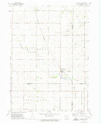 1972 Dougherty1975 Print · USGSNorth Iowa farm country at the start of the 1970s is defined by its rail connections and quiet township lines. Genealogists can locate family landmarks such as St Patricks Ch and West Fork Cem along the Chicago and North Western rail corridor.
End of results
Showing maps 1-1 of 1
Top cities near Dougherty
- Mason City historical maps
- Hampton historical maps
- Nora Springs historical maps
- Sheffield historical maps
- Rockwell historical maps
- Greene historical maps
See more
Frequently asked questions
- What are the different types of historical maps available for Dougherty?
- What is the oldest map of Dougherty?
- Where can I purchase historical maps of Dougherty for my home or office?
- Where can I download high-res historical maps of Dougherty?
- Are there historical topographic maps available for Dougherty?
- Is there historical aerial imagery available for Dougherty?
- Where are historical maps of Dougherty sourced from?