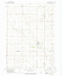
1972 Map of Dougherty
USGS Topo · Published 1975About this map
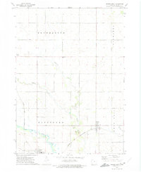
The Chicago and North Western railroad dictates the path of commerce through this agricultural landscape, connecting the small grain and rail stops of Dougherty and Cartersville. Situated at the intersection of Cerro Gordo, Floyd, Franklin, and Butler counties, the area is defined by the winding drainages of Coldwater Creek and West Fork Boylan Creek. Local life centers on established landmarks like St Patricks Ch, which stands near the northern edge of the Dougherty townsite. The southern portion of the survey reflects a rural community character, with the West Fork Cem and a small Gravel Pit serving the local township. This map provides a clear record of the North Iowa prairie before the modernization of the late 20th century, capturing the traditional survey lines of townships like Bennezette and Scott.
Find a feature on this map
21 named features on this map. Tap any name to fly to it.
Don’t see what you’re looking for? This feature index may not catch every label — zoom into the map to look around manually.
Map Details
Editions of this 1972 Dougherty Map
This is the sole edition of this map. No revisions or reprints were ever made.
Other maps of this area

1954 · Mason City
USGS Topo · 1:250,000

1954 · Waterloo
USGS Topo · 1:250,000

1955 · Waterloo
USGS Topo · 1:250,000

1957 · Mason City
USGS Topo · 1:250,000

1958 · Mason City
USGS Topo · 1:250,000
1959 · Mason City
USGS Topo · 1:62,500
1959 · Mason City SE
USGS Topo · 1:24,000
1959 · Hanford
USGS Topo · 1:24,000

1971 · Rockford
USGS Topo · 1:24,000
1972 · Dumont North
USGS Topo · 1:24,000