1980s Maps of Delmar, Iowa
Explore 4 historic maps of Delmar from the 1980s. These maps offer a rare glimpse into what life looked like during the 1980s — showing old roads, neighborhoods, homes, and landmarks that have changed or disappeared over time.
Whether you're researching your family's past, planning a metal detecting trip, or studying how Delmar's landscape evolved across the 1980s, these high-resolution maps are a powerful tool for exploring the history of this region.
- Focus on a specific era: All maps on this page are from the 1980s, giving you a focused view of this time period.
- See what’s changed: Compare century-old streets, trails, and buildings to today's modern landscape using overlays and satellite layers.
- Research with precision: Use these maps for genealogy, historical research, land use analysis, or educational projects.
- View, download, or print: Maps are fully viewable online in high resolution, and can be downloaded or printed for your own records.
Start exploring Delmar's history through authentic maps from the 1980s. This is your window into the past.
Delmar, IA maps
(4)- 1980 Map of Delmar South, 1981 Print
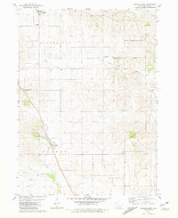 1980 Delmar South1981 Print · USGSClinton County’s agricultural heartland is documented here in the early eighties, showing the transition from active rail to retired transport corridors. Researchers can trace family history at Evergreen Cem, locate the Immaculate Conception Ch in Petersville, or follow the Old Railroad Grade.2 unique versions available
 - 1980 Map of Delmar North, 1981 Print
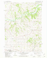 1980 Delmar North1981 Print · USGSJackson County in the late 1970s is documented here as a landscape of river valleys and rail-fed settlements. Genealogists can locate family burial sites at Codfish Cem or Rathbun Cem and trace the Chicago Milwaukee St Paul and Pacific tracks through Delmar.
 - 1984 Map of Dubuque South, 1985 Print
 1984 Dubuque South1985 Print · USGSEastern Iowa and Northwest Illinois meet along the Mississippi in the mid-eighties, a landscape defined by river industry and limestone bluffs. Trace the rail lines of the Illinois Central Gulf or explore notable sites like the Savanna Army Depot and Maquoketa Caves State Park.4 unique versions available
 - 1984 Map of Davenport, 1985 Print
 1984 Davenport1985 Print · USGSThe Quad Cities and the eastern Iowa riverlands are captured in the mid-eighties as industry and conservation converged along the Mississippi. Genealogists and local historians can trace rural roots through Stender Church, Oxford Mills, and the Elmwood Cem burial grounds.2 unique versions available
End of results
Showing maps 1-4 of 4
Top cities near Delmar
- Maquoketa historical maps
- De Witt historical maps
- DeWitt historical maps
- Preston historical maps
- Wheatland historical maps
- Grand Mound historical maps
See more
Frequently asked questions
- What are the different types of historical maps available for Delmar?
- What is the oldest map of Delmar?
- Where can I purchase historical maps of Delmar for my home or office?
- Where can I download high-res historical maps of Delmar?
- Are there historical topographic maps available for Delmar?
- Is there historical aerial imagery available for Delmar?
- Where are historical maps of Delmar sourced from?