Old Maps of Clinton County, Iowa
Explore 197 old maps of Clinton County, spanning from 1890 to today. These high-resolution historic maps reveal how streets, neighborhoods, landmarks, and natural features evolved over time — perfect for genealogy, metal detecting, research, and local history exploration.
What you can do with these maps:
- See how Clinton County changed over time: Compare historical maps to modern-day views to trace roads, homesites, rail lines & more.
- View detailed metadata: Each map includes creators, publishers, year, scale, and archive source.
- Overlay maps with satellite & LiDAR: Visualize the past alongside modern tools to explore terrain & human change.
- Trusted historical sources: Maps sourced from the USGS, Library of Congress, and other archives.
- Access maps your way: View online, download high-res files, or order prints for personal or research use.
Start exploring old maps of Clinton County to uncover forgotten places, hidden landmarks, and the deep history beneath your feet.
Clinton County, IA maps
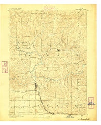
(197)- 1890 Map of Durant
 1890 Durant1890 Print · USGSEastern Iowa's rail-dependent farming communities are documented in the late nineteenth century as the grid of townships began to mature. Genealogists and historians can trace the early footprints of Durant, Walcott, and the remote Round Grove P.O. along established rail lines.
 - 1891 Map of DeWitt
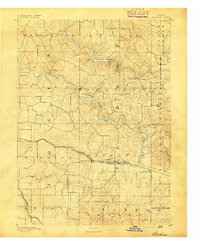
 1891 DeWitt1891 Print · USGSClinton County is shown here during the peak of its railroad expansion in the late nineteenth century. Researchers can trace the development of De Witt and find early platted details for Delmar, Elwood, and the junction at Grand Mound.3 unique versions available
 - 1891 Map of Davenport
 1891 Davenport1891 Print · USGSIowa's riverfront and rolling prairie townships are captured here during a period of rapid railroad expansion in the late nineteenth century. Trace early land tracts and rail junctions like Eldridge Junction or locate landmarks such as Green Tree Tavern and Maysville.
 - 1891 Map of Maquoketa
 1891 Maquoketa1891 Print · USGSJackson County, Iowa, was a thriving agricultural and rail corridor in the years following the Civil War. Trace the early streets of Maquoketa and locate rural landmarks like Cottonville, Andrew, and the river crossing at Bridgeport.3 unique versions available
 - 1891 Map of Baldwin
 1891 Baldwin1891 Print · USGSJackson County at the end of the century shows a rugged landscape transitioning from river-based industry to a railroad economy. Genealogists can trace family footprints in early settlements like Ozark, Clay Mills, and the rail hubs of Baldwin and Monmouth.3 unique versions available
 - 1891 Map of Clinton
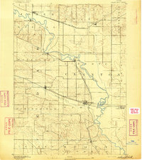
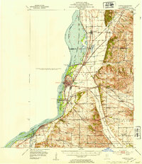
 1891 Clinton1891 Print · USGSThe Mississippi River corridor thrived as a dual-state rail hub in the 1890s, anchored by the riverfront centers of Clinton and Fulton. Researchers can trace the early tracks of the Chicago and Northwestern RR and locate vanished stops like Almont and Argo.
 - 1892 Map of Wheatland
 1892 Wheatland1892 Print · USGSEastern Iowa in the late nineteenth century was a landscape of burgeoning rail towns and river settlements. Genealogists and historians can trace early property boundaries and rail corridors through Wheatland, the winding Wapsipinicon River, and the curiously named Lost Nation.
 - 1892 Map of Goose Lake
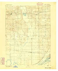
 1892 Goose Lake1892 Print · USGSClinton County thrived at the end of the nineteenth century as a hub of river commerce and expanding rail lines. Genealogists and local historians can trace the early development of Camanche on the Mississippi River or the inland rail stops of Charlotte and Low Moor.
 - 1892 Map of Savanna
 1892 Savanna1892 Print · USGSThe upper Mississippi corridor in the late nineteenth century was a bustling hub of river commerce and competing rail lines. Map enthusiasts can trace the old tracks of the Chicago Burlington and Northern Railroad and locate vanished landmarks like Hickory Grove or Idens Lake.8 unique versions available
 - 1892 Map of Leclaire
 1892 Leclaire1892 Print · USGSThe Mississippi River border between Iowa and Illinois comes alive in the 1890s, before modern locks reshaped the shoreline. Genealogists and historians can trace riverside settlements like Leclaire, Port Byron, and the railroad junction at Watertown.
 - 1893 Map of Leclaire
 1893 Leclaire1893 Print · USGSThe riverfronts of Scott County and Rock Island County thrived in the late nineteenth century as vital hubs for steamboats and steam rail. Researchers can trace the early grids of Leclaire, Port Byron, and Valley City alongside the sprawling banks of the Mississippi River.4 unique versions available
 - 1894 Map of Wheatland
 1894 Wheatland1894 Print · USGSClinton and Jones counties thrived along the river and rail corridors of the 1890s. Genealogists can trace the early development of Oxford Junction and Wheatland, or locate old mill sites near Oxford Mills and Massillon.2 unique versions available
 - 1894 Map of Durant
 1894 Durant1894 Print · USGSAgricultural towns and pioneering rail lines define this Iowa landscape in the 1890s. Family historians can trace early settlements and transit hubs from Durant and Walcott to the rural Round Grove P.O. and Pleasant Prairie.2 unique versions available
 - 1894 Map of Goose Lake
 1894 Goose Lake1894 Print · USGSClinton County and the banks of the Mississippi are shown here in the 1890s as the railroad and river trade defined local growth. Researchers can trace the original footprints of settlements like Charlotte, Low Moor, and the river landing at Camanche.3 unique versions available
 - 1894 Map of Clinton
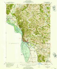
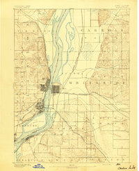 1894 Clinton1894 Print · USGSThe riverfront communities of eastern Iowa and western Illinois are captured here in the late nineteenth century as rail expansion reached its peak. Researchers can trace early street grids in Clinton and Lyons or locate old rail junctions near Garden Plain and Almont.3 unique versions available
 - 1894 Map of Davenport
 1894 Davenport1894 Print · USGSDavenport and the surrounding Scott County prairies come alive in this late nineteenth-century survey of the Mississippi River front. Researchers can trace the early rail networks through Eldridge Junction and locate vanished landmarks like Green Tree Tavern and Gilbertown.4 unique versions available
 - 1899 Map of Clinton
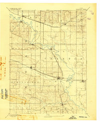
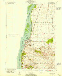
 1899 Clinton1899 Print · USGSThe Mississippi River valley comes alive in the late 1890s, capturing the river-and-rail economy of Iowa and Illinois before modern channelization. Genealogists and historians can trace early townships and river landings, finding precise locations for Low Moor, Folletts, and Pink Prairie.5 unique versions available
 - 1901 Map of Peosta
 1901 Peosta1901 Print · USGSDubuque and Jackson counties were a hub of river commerce and early rail expansion at the turn of the century. Genealogists and historians can trace the foundations of communities like Peosta, St.Donatus, and the mill sites at Washington Mills.4 unique versions available
 - 1901 Map of Rock Island
 1901 Rock Island1901 Print · USGSThe eastern Iowa borderlands and the Mississippi River confluence thrive during the rail boom of the late nineteenth century. Genealogists and historians can trace family roots through numerous small settlements like Lost Nation, Grand Mound, and the vital U. S. Arsenal grounds.2 unique versions available
 - 1910 Map of Rock Island, 1949 Print
 1910 Rock Island1949 Print · USGSEastern Iowa and the Illinois borderlands come alive in this late nineteenth-century survey of the river valleys and rail hubs. Genealogists and historians can trace old homesteads near Lost Nation, the early streets of Dewitt, and the sprawling U.S. Arsenal.
 - 1935 Map of Miles, 1957 Print
 1935 Miles1957 Print · USGSIn the mid-1930s, the Mississippi River shoreline was defined by military expansion and the rail economy. Genealogists and historians can trace the foundations of the Savanna Ordnance Depot and local landmarks like Whitton and Lost Mound Sch.
 - 1941 Map of Miles
 1941 Miles1941 Print · USGSThe Mississippi River borderlands come alive in this pre-war survey, documenting the small settlements and rail lines that defined the Jo Daviess and Carroll County line. Researchers can trace the river's complex island system or find local landmarks like Whitton, Lost Mound, and the Lost Mound Sch.2 unique versions available
 - 1952 Map of Clinton, 1953 Print
 1952 Clinton1953 Print · USGSThe Illinois-Iowa border along the Mississippi River is captured here in the early fifties, showing a landscape defined by industrial rail lines and wildlife refuges. Trace family roots through specific rural landmarks like York Ch, Cottonwood Sch, and Calvary Cem.2 unique versions available
 - 1952 Map of Cordova, 1953 Print
 1952 Cordova1953 Print · USGSRock Island County shoreline life is captured here in the early fifties, following the river as it winds past developing river towns. Genealogists can locate family landmarks like Williams Sch, Fairfield Ch, and the Baker Cem.
 - 1952 Map of Savanna, 1954 Print
 1952 Savanna1954 Print · USGSThe Mississippi River bluffs and rail corridors define this Illinois riverfront during the early fifties. Genealogists and historians can trace numerous rural schoolhouses and family-named cemeteries like Massbach Cem, Palsgrove, and the sprawling Savanna Ordnance Depot.3 unique versions available
Showing maps 1-25 of 197
Top cities of Clinton County
- Clinton historical maps
- DeWitt historical maps
- Camanche historical maps
- Wheatland historical maps
- Grand Mound historical maps
- Delmar historical maps
See more
Frequently asked questions
- What are the different types of historical maps available for Clinton County?
- What is the oldest map of Clinton County?
- Where can I purchase historical maps of Clinton County for my home or office?
- Where can I download high-res historical maps of Clinton County?
- Are there historical topographic maps available for Clinton County?
- Is there historical aerial imagery available for Clinton County?
- Where are historical maps of Clinton County sourced from?