1990s Maps of Clinton County, Iowa
Explore 11 historic maps of Clinton County from the 1990s. These maps offer a rare glimpse into what life looked like during the 1990s — showing old roads, neighborhoods, homes, and landmarks that have changed or disappeared over time.
Whether you're researching your family's past, planning a metal detecting trip, or studying how Clinton County's landscape evolved across the 1990s, these high-resolution maps are a powerful tool for exploring the history of this region.
- Focus on a specific era: All maps on this page are from the 1990s, giving you a focused view of this time period.
- See what’s changed: Compare century-old streets, trails, and buildings to today's modern landscape using overlays and satellite layers.
- Research with precision: Use these maps for genealogy, historical research, land use analysis, or educational projects.
- View, download, or print: Maps are fully viewable online in high resolution, and can be downloaded or printed for your own records.
Start exploring Clinton County's history through authentic maps from the 1990s. This is your window into the past.
Clinton County, IA maps
(11)- 1991 Map of Dixon, 1992 Print
 1991 Dixon1992 Print · USGSScott County and the border of Clinton County are captured here in the early nineties, centered on the community of Dixon. Local historians can trace the rural layouts of Plainview and New Liberty or locate family sites at Hope Ch and Memorial Park.
 - 1991 Map of Donahue, 1992 Print
 1991 Donahue1992 Print · USGSScott County farm country is captured here in the early nineties, centered on the rural junctions of Donahue and Maysville. Genealogists and researchers can trace family lands near Allens Grove Cem, locate the John Glenn Sch, or find the Stender Landing Field near the Hickory Grove line.
 - 1991 Map of Grand Mound, 1992 Print
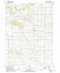
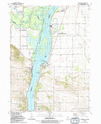
 1991 Grand Mound1992 Print · USGSClinton and Scott counties meet along the Wapsipinicon River in the early nineties, where small-town life centers on Grand Mound. Genealogists can trace family footprints across several rural burial grounds including Kvindherred Cem, Our Saviors Ch, and Evergreen Cem.
 - 1991 Map of Clinton, 1992 Print
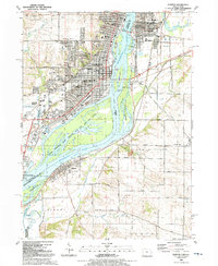 1991 Clinton1992 Print · USGSThe Mississippi River corridor comes alive in the early nineties, showcasing the riverfront growth of Iowa and Illinois. Genealogists can trace local roots through Clinton Mem Cem, St Patrick Ch, and school sites like Unity Christian High Sch.
 - 1991 Map of Lowden, 1992 Print
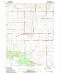
 1991 Lowden1992 Print · USGSEastern Iowa farmland centered on the railroad town of Lowden is documented here just before the turn of the millennium. Researchers can trace rural family plots and community hubs like Inland Cem, Zion Ch, and the waters of Yankee Run.
 - 1991 Map of Wheatland, 1992 Print
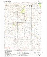
 1991 Wheatland1992 Print · USGSClinton and Scott counties in the early nineties show a landscape defined by the winding Wapsipinicon River and local rail lines. Researchers can find old rural cemeteries like Pine Hill Cem and landmarks such as the High Rock Bridge.
 - 1991 Map of Camanche, 1992 Print
 1991 Camanche1992 Print · USGSCamanche and the Clinton County riverfront are captured here in the early nineties, showcasing a region defined by the Mississippi and its surrounding townships. Genealogists can trace family sites at Pleasant Hill Cem or the settlement of Low Moor near the Chicago and North Western rail line.
 - 1991 Map of Mc Causland, 1992 Print
 1991 Mc Causland1992 Print · USGSThe rural borderlands of Scott and Clinton counties come into focus in the early nineties, centered on the Wapsipinicon River valley. Genealogists and local historians can trace rural settlements like McCausland and Argo, as well as landmarks like Fessler Cem and the historic Territorial Road.
 - 1991 Map of Malone, 1992 Print
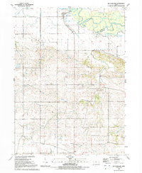
 1991 Malone1992 Print · USGSClinton County’s agricultural heartland is documented here in the early nineties, centered on the settlement of Malone and the Wapsipinicon River bottomlands. Genealogists can trace several family-named burial grounds like Cousin-Smith Cem and Bowers-Dannatt-Hill Cem.
 - 1991 Map of De Witt, 1992 Print
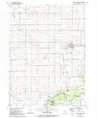
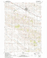
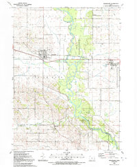
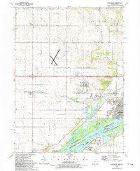
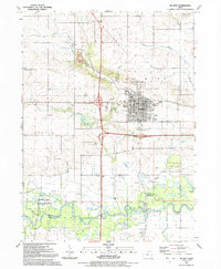 1991 De Witt1992 Print · USGSDe Witt flourished as a regional center in the early 1990s, anchored by its civic core and the expansive river valley to the south. Researchers can trace the town's growth through landmarks like Ekstrand School and Elmwood Cemetery or explore the wetlands along the Wapsipinicon River.
 - 1991 Map of Cordova, 1992 Print
 1991 Cordova1992 Print · USGSThe riverfront communities of Rock Island and Scott counties are captured here in the late twentieth century as industry and recreation converge. Researchers can trace local heritage through sites like Virgil Grissom Sch, Our Lady of the River Ch, and Jacks Cem.
End of results
Showing maps 1-11 of 11
Top cities of Clinton County
- Clinton historical maps
- DeWitt historical maps
- Camanche historical maps
- Wheatland historical maps
- Grand Mound historical maps
- Delmar historical maps
See more
Frequently asked questions
- What are the different types of historical maps available for Clinton County?
- What is the oldest map of Clinton County?
- Where can I purchase historical maps of Clinton County for my home or office?
- Where can I download high-res historical maps of Clinton County?
- Are there historical topographic maps available for Clinton County?
- Is there historical aerial imagery available for Clinton County?
- Where are historical maps of Clinton County sourced from?