1970s Maps of Denison, Iowa
Explore 4 historic maps of Denison from the 1970s. These maps offer a rare glimpse into what life looked like during the 1970s — showing old roads, neighborhoods, homes, and landmarks that have changed or disappeared over time.
Whether you're researching your family's past, planning a metal detecting trip, or studying how Denison's landscape evolved across the 1970s, these high-resolution maps are a powerful tool for exploring the history of this region.
- Focus on a specific era: All maps on this page are from the 1970s, giving you a focused view of this time period.
- See what’s changed: Compare century-old streets, trails, and buildings to today's modern landscape using overlays and satellite layers.
- Research with precision: Use these maps for genealogy, historical research, land use analysis, or educational projects.
- View, download, or print: Maps are fully viewable online in high resolution, and can be downloaded or printed for your own records.
Start exploring Denison's history through authentic maps from the 1970s. This is your window into the past.
Denison, IA maps
(4)- 1971 Map of Earling NE, 1973 Print
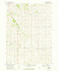 1971 Earling NE1973 Print · USGSCrawford County's rural townships are captured in the early 1970s during a period of steady agricultural production and infrastructure development. Genealogists can trace family footprints at Zion Cem and Township Cem, while rail enthusiasts can follow the Chicago Milwaukee St Paul and Pacific line.
 - 1971 Map of Denison, 1973 Print
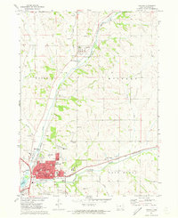 1971 Denison1973 Print · USGSDenison and the Boyer River valley are shown in the early seventies, at the busy junction of two major Midwestern rail lines. Researchers can trace family history through several local burial grounds, including Milford Cem, and find old landmarks like the Zion Sch and Our Savior Ch.
 - 1971 Map of Dow City, 1973 Print
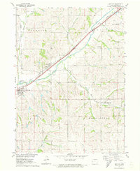 1971 Dow City1973 Print · USGSCrawford County's rail-and-river network is on full display in the early seventies, featuring the convergence of three major railroads. Genealogists and local historians can trace the foundations of Dow City, Arion, and Buck Grove, or locate family sites like Butler Cem.
 - 1971 Map of Denison SW, 1973 Print
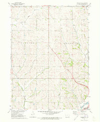 1971 Denison SW1973 Print · USGSCrawford County's rolling farmland and river valleys are captured here in the early seventies, showing the rural township boundaries of Morgan and Hanover. Trace the C & NW rail line as it follows the Boyer River past a local Gravel Pit.
End of results
Showing maps 1-4 of 4
Top cities near Denison
- Schleswig historical maps
- Manilla historical maps
- Dow City historical maps
- Earling historical maps
- Vail historical maps
- Irwin historical maps
See more
Frequently asked questions
- What are the different types of historical maps available for Denison?
- What is the oldest map of Denison?
- Where can I purchase historical maps of Denison for my home or office?
- Where can I download high-res historical maps of Denison?
- Are there historical topographic maps available for Denison?
- Is there historical aerial imagery available for Denison?
- Where are historical maps of Denison sourced from?