1980s Maps of Dallas County, Iowa
Explore 11 historic maps of Dallas County from the 1980s. These maps offer a rare glimpse into what life looked like during the 1980s — showing old roads, neighborhoods, homes, and landmarks that have changed or disappeared over time.
Whether you're researching your family's past, planning a metal detecting trip, or studying how Dallas County's landscape evolved across the 1980s, these high-resolution maps are a powerful tool for exploring the history of this region.
- Focus on a specific era: All maps on this page are from the 1980s, giving you a focused view of this time period.
- See what’s changed: Compare century-old streets, trails, and buildings to today's modern landscape using overlays and satellite layers.
- Research with precision: Use these maps for genealogy, historical research, land use analysis, or educational projects.
- View, download, or print: Maps are fully viewable online in high resolution, and can be downloaded or printed for your own records.
Start exploring Dallas County's history through authentic maps from the 1980s. This is your window into the past.
Dallas County, IA maps
(11)- 1982 Map of Panther, 1983 Print
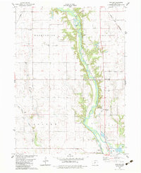 1982 Panther1983 Print · USGSDallas County farm country and the Raccoon River valley are captured here in the early 1980s. Researchers can trace rural landmarks from Panther to Blacks Corners, including old country anchors like Washington Chapel and Central Dallas Sch.
 - 1982 Map of Panora, 1983 Print
 1982 Panora1983 Print · USGSGuthrie County during the early eighties shows a transition from traditional rail-corridor farming to lakeside recreation. Trace family history at Greenwood Cem or follow the Chicago and North Western line through Panora and Linden.
 - 1982 Map of Yale, 1983 Print
 1982 Yale1983 Print · USGSGuthrie County and its neighbors are shown here in the early eighties, centered on the vital rail corridor connecting Yale and Jamaica. Researchers can trace old family sites near Richland Cemetery or explore the wetlands of Lakin Slough.
 - 1982 Map of Redfield, 1983 Print
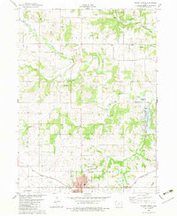
 1982 Redfield1983 Print · USGSRedfield and Dexter flourished as rail and river towns in the early 1980s, serving as industrial and agricultural centers for Dallas County. Genealogists and historians can trace local family lineages through several rural burial grounds, including Harper Cem, Spillers Cem, and the historic Bear Creek Ch.
 - 1982 Map of Perry, 1983 Print
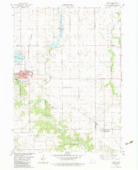
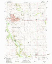 1982 Perry1983 Print · USGSPerry and its surrounding Dallas County townships thrived as a vital railroad junction in the early 1980s. Local researchers can map out the city's growth through its many neighborhood schools like Lincoln Sch or trace rural roots at Violet Hill Cem and Elmwood Cem.
 - 1982 Map of Adel, 1983 Print
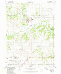
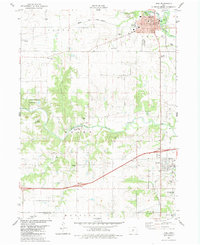 1982 Adel1983 Print · USGSDallas County during the early eighties shows the settled river valleys and growing towns of Adel and De Soto. Genealogists can trace family plots at Oakdale Cem or Gibson Cem, while historians can map the path of the Chicago and North Western railroad.
 - 1982 Map of Stuart North, 1983 Print
 1982 Stuart North1983 Print · USGSGuthrie and Adair counties come into focus in the early eighties as the rail-and-river economy centers on the town of Stuart. Researchers can trace the path of the Iowa Railroad or locate family plots at Morrisburg Cem and North Oak Grove Cem.
 - 1982 Map of Dawson, 1983 Print
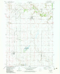
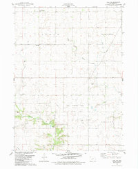
 1982 Dawson1983 Print · USGSThe Raccoon River valley in the early 1980s reveals a structured landscape of rail-connected towns and rural townships. Researchers can pinpoint historic burial grounds like Angus Cem and trace the Chicago and North Western line through Dawson.
 - 1982 Map of Adel NW, 1983 Print
 1982 Adel NW1983 Print · USGSDallas County agriculture and energy infrastructure meet in the early eighties as rural townships transition toward modern utility roles. Genealogists and local historians can trace the West Linn Cem, visit the Shiloh Bible Ch, and locate the old Linden settlement.
 - 1984 Map of Des Moines, 1985 Print
 1984 Des Moines1985 Print · USGSCentral Iowa's heartland is captured in the mid-1980s as suburban growth met long-standing farm and rail infrastructure. Genealogists and researchers can trace the reaches of the Chicago and North Western through Maxwell or locate Laurel Hill Cem and Camp Dodge Military Reservation.2 unique versions available
 - 1984 Map of Guthrie Center, 1985 Print
 1984 Guthrie Center1985 Print · USGSWest-central Iowa's river valleys and farming townships are shown here in the mid-1980s, highlighting a network of conservation areas and historic rail towns. Genealogists and local historians can locate Violet Hill Cem, trace the Chicago and North Western railroad, or explore the grounds of Springbrook State Park.
End of results
Showing maps 1-11 of 11
Top cities of Dallas County
Frequently asked questions
- What are the different types of historical maps available for Dallas County?
- What is the oldest map of Dallas County?
- Where can I purchase historical maps of Dallas County for my home or office?
- Where can I download high-res historical maps of Dallas County?
- Are there historical topographic maps available for Dallas County?
- Is there historical aerial imagery available for Dallas County?
- Where are historical maps of Dallas County sourced from?