1970s Maps of Dows, Iowa
Explore 2 historic maps of Dows from the 1970s. These maps offer a rare glimpse into what life looked like during the 1970s — showing old roads, neighborhoods, homes, and landmarks that have changed or disappeared over time.
Whether you're researching your family's past, planning a metal detecting trip, or studying how Dows's landscape evolved across the 1970s, these high-resolution maps are a powerful tool for exploring the history of this region.
- Focus on a specific era: All maps on this page are from the 1970s, giving you a focused view of this time period.
- See what’s changed: Compare century-old streets, trails, and buildings to today's modern landscape using overlays and satellite layers.
- Research with precision: Use these maps for genealogy, historical research, land use analysis, or educational projects.
- View, download, or print: Maps are fully viewable online in high resolution, and can be downloaded or printed for your own records.
Start exploring Dows's history through authentic maps from the 1970s. This is your window into the past.
Dows, IA maps
(2)- 1978 Map of Dows West, 1979 Print
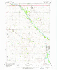 1978 Dows West1979 Print · USGSWright County in the late 1970s is defined by its precision-drained farmland and the winding Iowa River. Trace the history of small-town life and transport through the rail corridors of Rowan and Galt, and locate ancestral sites like Graceland Cem.
 - 1979 Map of Dows East, 1980 Print
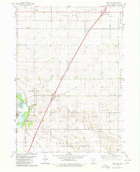 1979 Dows East1980 Print · USGSFranklin County's rural townships and the riverside community of Dows are captured here in the late seventies. Genealogists and local historians can locate family plots at Mount Hope Cem or trace the paths of the Chicago and North-Western and Chicago Rock Island and Pacific railroads.
End of results
Showing maps 1-2 of 2
Top cities near Dows
- Iowa Falls historical maps
- Clarion historical maps
- Belmond historical maps
- Alden historical maps
- Latimer historical maps
- Williams historical maps
See more
Frequently asked questions
- What are the different types of historical maps available for Dows?
- What is the oldest map of Dows?
- Where can I purchase historical maps of Dows for my home or office?
- Where can I download high-res historical maps of Dows?
- Are there historical topographic maps available for Dows?
- Is there historical aerial imagery available for Dows?
- Where are historical maps of Dows sourced from?