1980s Maps of Waucoma, Iowa
Explore 2 historic maps of Waucoma from the 1980s. These maps offer a rare glimpse into what life looked like during the 1980s — showing old roads, neighborhoods, homes, and landmarks that have changed or disappeared over time.
Whether you're researching your family's past, planning a metal detecting trip, or studying how Waucoma's landscape evolved across the 1980s, these high-resolution maps are a powerful tool for exploring the history of this region.
- Focus on a specific era: All maps on this page are from the 1980s, giving you a focused view of this time period.
- See what’s changed: Compare century-old streets, trails, and buildings to today's modern landscape using overlays and satellite layers.
- Research with precision: Use these maps for genealogy, historical research, land use analysis, or educational projects.
- View, download, or print: Maps are fully viewable online in high resolution, and can be downloaded or printed for your own records.
Start exploring Waucoma's history through authentic maps from the 1980s. This is your window into the past.
Waucoma, IA maps
(2)- 1981 Map of Waucoma, 1982 Print
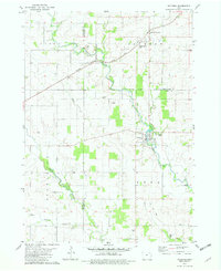 1981 Waucoma1982 Print · USGSNortheast Iowa’s river-carved farmland is documented here in the early eighties at the intersection of three counties. Genealogists and local historians can trace the foundations of Waucoma, locate the Turkey Valley Community Sch, and find rural landmarks like St Johns Ch.
 - 1985 Map of Charles City
 1985 Charles City1985 Print · USGSNorthern Iowa and the Minnesota borderlands are mapped here in the mid-1980s as a thriving network of rail-side towns and river valleys. Trace local history through the Reilly Settlement, Stacyville Junction, and aviation sites like Ellen Church Field.2 unique versions available
End of results
Showing maps 1-2 of 2
Top cities near Waucoma
- Decorah historical maps
- West Union historical maps
- Sumner historical maps
- Fayette historical maps
- Calmar historical maps
- Fredericksburg historical maps
See more
Frequently asked questions
- What are the different types of historical maps available for Waucoma?
- What is the oldest map of Waucoma?
- Where can I purchase historical maps of Waucoma for my home or office?
- Where can I download high-res historical maps of Waucoma?
- Are there historical topographic maps available for Waucoma?
- Is there historical aerial imagery available for Waucoma?
- Where are historical maps of Waucoma sourced from?