1900s (20th Century) Maps of Greene County, Iowa
Explore 35 historic maps of Greene County from the 1900s (20th Century). These maps offer a rare glimpse into what life looked like during the 1900s — showing old roads, neighborhoods, homes, and landmarks that have changed or disappeared over time.
Whether you're researching your family's past, planning a metal detecting trip, or studying how Greene County's landscape evolved across the 1900s, these high-resolution maps are a powerful tool for exploring the history of this region.
- Focus on a specific era: All maps on this page are from the 1900s, giving you a focused view of this time period.
- See what’s changed: Compare century-old streets, trails, and buildings to today's modern landscape using overlays and satellite layers.
- Research with precision: Use these maps for genealogy, historical research, land use analysis, or educational projects.
- View, download, or print: Maps are fully viewable online in high resolution, and can be downloaded or printed for your own records.
Start exploring Greene County's history through authentic maps from the 1900s. This is your window into the past.
Greene County, IA maps
(35)- 1950 Map of Perry, 1968 Print
 1950 Perry1968 Print · USGSMid-century Dallas and Boone Counties are captured here at a peak of rural development, showing a landscape defined by prairie agriculture and heavy rail. Genealogists can trace family footprints across dozens of country schools like Garfield Sch and churches including Swede Valley Ch.
 - 1951 Map of Perry
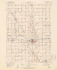 1951 Perry1951 Print · USGSMid-century central Iowa comes into focus in this detailed study of the rail and river corridors surrounding Perry. Genealogists and historians can trace the locations of dozens of country schools and cemeteries, from Prairie View Sch to the Violet Hill Cem.2 unique versions available
 - 1951 Map of Ogden
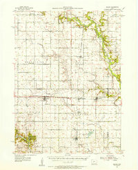
 1951 Ogden1951 Print · USGSCentral Iowa's farming heartland is captured here in the early fifties, showing a landscape defined by the intersection of the Chicago North Western and the Fort Dodge Des Moines and Southern. Researchers can trace vanished rural schoolhouses like Kelly Sch and the family history tied to Union Cem or Boxholm.3 unique versions available
 - 1954 Map of Bagley, 1956 Print
 1954 Bagley1956 Print · USGSGuthrie and Greene counties are shown in the mid-fifties as the railroad network still linked small agricultural towns. Genealogists can trace family roots through Greenbrier Cem and St Marys Ch or locate the many Flowing Well sites across the prairie.
 - 1954 Map of Omaha, 1967 Print
 1954 Omaha1967 Print · USGSMid-century development radiates from the river bluffs into the agricultural heartland during this period of post-war growth. Genealogists and historians can trace rail-connected towns like Atlantic and Red Oak or locate the sprawling grounds of Offutt Air Force Base and Manawa Lake.3 unique versions available
 - 1954 Map of Fort Dodge, 1968 Print
 1954 Fort Dodge1968 Print · USGSNorthwest Iowa is shown here during a period of steady industrial and rail activity in the mid-fifties. Researchers can trace the extensive rail lines connecting Fort Dodge to mining and manufacturing sites like Gypsum and Industry Station.3 unique versions available
 - 1957 Map of Omaha
 1957 Omaha1957 Print · USGSWestern Iowa and the Missouri River valley are seen here in the mid-fifties during the height of the rail-and-road era. Researchers can trace the sprawling rail lines of the Chicago And North Western or locate Cold War landmarks like Offutt Air Force Base.
 - 1957 Map of Fort Dodge
 1957 Fort Dodge1957 Print · USGSWest-central Iowa thrived as a network of rail-linked agricultural hubs and river towns during the mid-fifties. Researchers can trace the development of the Des Moines River valley and locate historic landmarks in Fort Dodge, Storm Lake, and Lehigh.
 - 1958 Map of Omaha
 1958 Omaha1958 Print · USGSOmaha and Council Bluffs stand at the center of this mid-fifties landscape, where the Missouri River splits the urban plains of Nebraska from the rolling hills of western Iowa. Genealogists can trace the rail lines of the Wabash RR and Illinois Central RR to rural settlements like Missouri Valley and Red Oak.2 unique versions available
 - 1958 Map of Fort Dodge
 1958 Fort Dodge1958 Print · USGSWestern Iowa in the mid-1950s reveals a productive landscape of river-valley industry and prairie agricultural hubs. Researchers can trace the development of the Des Moines River corridor through Fort Dodge and locate vanished local landmarks near Coalville or Storm Lake.
 - 1962 Map of Jefferson, 1964 Print
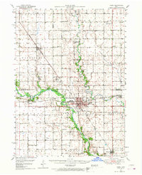
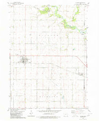
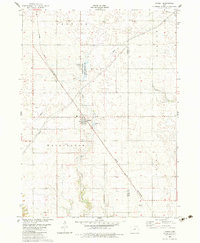
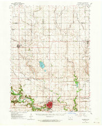 1962 Jefferson1964 Print · USGSGreene County agriculture and rail commerce are at their peak in the early sixties as steam gives way entirely to diesel. Genealogists can locate family plots at Golgotha Cem, trace the rural North Sch, or explore the wetland edges of Goose Lake State Preserve.
 - 1971 Map of Coon Rapids South, 1973 Print
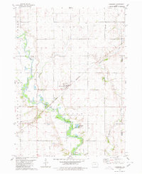
 1971 Coon Rapids South1973 Print · USGSGuthrie and Carroll counties come together in the early seventies as the rail-and-river economy centers on Coon Rapids. Researchers can trace old family plots at Tuttles Grove Cem or locate the rural Townhall near the banks of Brushy Creek.
 - 1971 Map of Coon Rapids NE, 1973 Print
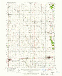
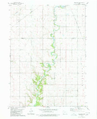
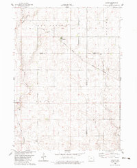
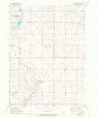 1971 Coon Rapids NE1973 Print · USGSGreene County agriculture and water management are on full display in the early 1970s. Local researchers can locate family sites near Trinity Ch and Willow Cem, or trace the path of Dunbar Slough.
 - 1971 Map of Coon Rapids North, 1973 Print
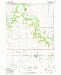
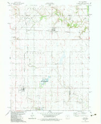
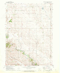 1971 Coon Rapids North1973 Print · USGSCarroll and Greene counties in the early 1970s are defined by the winding Middle Raccoon River and a strong rail presence. Genealogists and local historians can trace family roots through Old Carrollton Cem, Union Cem, and the rural Pleasant Ridge Ch.
 - 1971 Map of Bayard, 1973 Print
 1971 Bayard1973 Print · USGSBayard and the surrounding Guthrie County townships are shown in the early 1970s, defined by the Chicago Milwaukee St Paul and Pacific rail line. Researchers can locate the Highland Cem, trace the Middle Raccoon River, or explore the Mc Cord Pond State Wildlife Management Area.
 - 1980 Map of Glidden
 1980 Glidden1980 Print · USGSAgricultural Carroll County comes to life in this late twentieth-century survey of the heartland's rail and river systems. Genealogists and local historians can trace the Chicago and North Western line through Glidden and locate family markers at Dickson Cem.
 - 1980 Map of Wightman
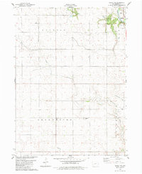
 1980 Wightman1980 Print · USGSCalhoun and Greene counties appear at a crossroads in the early 1980s where the Iowa rail network meets the agricultural heartland. Researchers can trace the village of Wightman, follow the Chicago and North Western tracks, and locate St Patricks Ch.
 - 1980 Map of Scranton
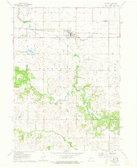
 1980 Scranton1980 Print · USGSGreene County agriculture and the river valley define this landscape in the early eighties. Genealogists and historians can trace the Chicago and North Western rail line through Scranton, or locate family sites near Dillavou Cem and Friends Ch.
 - 1980 Map of Lanesboro
 1980 Lanesboro1980 Print · USGSLanesboro and the surrounding Carroll County farmland are captured here in the late 1970s as the rail and river networks shaped local life. Genealogists and historians can locate Lanesboro Cem, trace the Chicago and North Western rail line, or find local landmarks like Vador Bridge.
 - 1982 Map of Rippey, 1983 Print
 1982 Rippey1983 Print · USGSRippey and the surrounding Iowa farmland are documented here in the early eighties at a significant rail crossroads. Genealogists and local historians can trace the paths of the Chicago and North Western railroad or locate sites like the cemetery and Angus.
 - 1982 Map of Lanyon, 1983 Print
 1982 Lanyon1983 Print · USGSGreene and Webster counties are captured here in the early eighties, showing a landscape of precise section grids and prairie streams. Genealogists can locate Township Cem and Renner Cem, or trace the rail sidings in Lanyon and Hope.
 - 1982 Map of Yale, 1983 Print
 1982 Yale1983 Print · USGSGuthrie County and its neighbors are shown here in the early eighties, centered on the vital rail corridor connecting Yale and Jamaica. Researchers can trace old family sites near Richland Cemetery or explore the wetlands of Lakin Slough.
 - 1982 Map of Bagley NW, 1983 Print
 1982 Bagley NW1983 Print · USGSGreene County agricultural lands and the North Raccoon River corridor are captured here in the early 1980s. Researchers can locate family landmarks such as Greenbrier United Ch and the German Cem, or trace the winding paths of Dead Brier Creek.
 - 1982 Map of Grand Junction, 1983 Print
 1982 Grand Junction1983 Print · USGSGrand Junction and its surrounding townships are shown here in the early eighties, centered on the critical rail crossing and local agricultural hubs. Researchers can trace family roots at Mount Calvary Cem or locate the rural siding at Dana and the settlement of Beaver.
 - 1982 Map of Dawson, 1983 Print
 1982 Dawson1983 Print · USGSThe Raccoon River valley in the early 1980s reveals a structured landscape of rail-connected towns and rural townships. Researchers can pinpoint historic burial grounds like Angus Cem and trace the Chicago and North Western line through Dawson.
Showing maps 1-25 of 35
Frequently asked questions
- What are the different types of historical maps available for Greene County?
- What is the oldest map of Greene County?
- Where can I purchase historical maps of Greene County for my home or office?
- Where can I download high-res historical maps of Greene County?
- Are there historical topographic maps available for Greene County?
- Is there historical aerial imagery available for Greene County?
- Where are historical maps of Greene County sourced from?