1970s Maps of Independence Township, Iowa
Explore 2 historic maps of Independence Township from the 1970s. These maps offer a rare glimpse into what life looked like during the 1970s — showing old roads, neighborhoods, homes, and landmarks that have changed or disappeared over time.
Whether you're researching your family's past, planning a metal detecting trip, or studying how Independence Township's landscape evolved across the 1970s, these high-resolution maps are a powerful tool for exploring the history of this region.
- Focus on a specific era: All maps on this page are from the 1970s, giving you a focused view of this time period.
- See what’s changed: Compare century-old streets, trails, and buildings to today's modern landscape using overlays and satellite layers.
- Research with precision: Use these maps for genealogy, historical research, land use analysis, or educational projects.
- View, download, or print: Maps are fully viewable online in high resolution, and can be downloaded or printed for your own records.
Start exploring Independence Township's history through authentic maps from the 1970s. This is your window into the past.
Independence Township, IA maps
(2)- 1978 Map of Blairsburg, 1979 Print
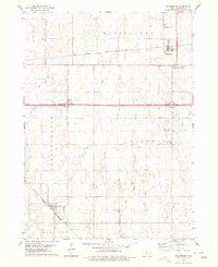 1978 Blairsburg1979 Print · USGSHamilton County agriculture and rail systems are clearly defined in the late seventies. Family historians can locate specific landmarks like Blairsburg Cem, First United Ch, and the rail junction at Kamrar as they appeared decades ago.
 - 1978 Map of Webster City, 1979 Print
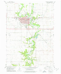 1978 Webster City1979 Print · USGSWebster City is captured here during the late seventies, showing the vital intersection of the Boone River and two major rail lines. Genealogists and local historians can locate family plots in Graceland Cem or trace neighborhood growth near Lawn Hill Sch and the Fairground.
End of results
Showing maps 1-2 of 2
Top cities near Independence Township
- Webster City historical maps
- Eagle Grove historical maps
- Jewell Junction historical maps
- Jewell historical maps
- Stratford historical maps
- Ellsworth historical maps
See more
Top neighborhoods of Independence Township
Frequently asked questions
- What are the different types of historical maps available for Independence Township?
- What is the oldest map of Independence Township?
- Where can I purchase historical maps of Independence Township for my home or office?
- Where can I download high-res historical maps of Independence Township?
- Are there historical topographic maps available for Independence Township?
- Is there historical aerial imagery available for Independence Township?
- Where are historical maps of Independence Township sourced from?