
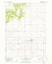
1978 Map of Blairsburg
USGS Topo · Published 1979About this map
The town of Blairsburg and the smaller settlement of Kamrar anchor this Hamilton County landscape in the late 1970s. The map captures an era of evolving transportation and agricultural drainage, where the Illinois Central Gulf and Chicago and North Western rail lines cross the prairie. A complex network of water management is visible through numerous engineered channels, including Ditch No 208 and Ditch No 63, which support the intensive farming found in the townships of Blairsburg and Liberty. Cultural landmarks such as the First United Ch and the Community Hall provide a sense of local community centers. For genealogists and researchers, the map clearly identifies the Blairsburg Cem and Liberty Center Cem, alongside the small stop at Stonega. The headwaters of the Skunk River appear in the eastern portion of the sheet, winding through the grid-like organization of the Iowa countryside.
Find a feature on this map
23 named features on this map. Tap any name to fly to it.
Don’t see what you’re looking for? This feature index may not catch every label — zoom into the map to look around manually.
Map Details
Editions of this 1978 Blairsburg Map
This is the sole edition of this map. No revisions or reprints were ever made.
Other maps of this area

1954 · Waterloo
USGS Topo · 1:250,000

1955 · Waterloo
USGS Topo · 1:250,000

1978 · Woolstock
USGS Topo · 1:24,000

1978 · Ellsworth
USGS Topo · 1:24,000

1978 · Webster City
USGS Topo · 1:24,000

1978 · Sheldon Creek
USGS Topo · 1:24,000
1978 · Stanhope
USGS Topo · 1:24,000

1978 · Jewell
USGS Topo · 1:24,000

1978 · Clarion SW
USGS Topo · 1:24,000

1978 · Williams
USGS Topo · 1:24,000