1970s Maps of Jewell Junction, Iowa
Explore 2 historic maps of Jewell Junction from the 1970s. These maps offer a rare glimpse into what life looked like during the 1970s — showing old roads, neighborhoods, homes, and landmarks that have changed or disappeared over time.
Whether you're researching your family's past, planning a metal detecting trip, or studying how Jewell Junction's landscape evolved across the 1970s, these high-resolution maps are a powerful tool for exploring the history of this region.
- Focus on a specific era: All maps on this page are from the 1970s, giving you a focused view of this time period.
- See what’s changed: Compare century-old streets, trails, and buildings to today's modern landscape using overlays and satellite layers.
- Research with precision: Use these maps for genealogy, historical research, land use analysis, or educational projects.
- View, download, or print: Maps are fully viewable online in high resolution, and can be downloaded or printed for your own records.
Start exploring Jewell Junction's history through authentic maps from the 1970s. This is your window into the past.
Jewell Junction, IA maps
(2)- 1978 Map of Ellsworth, 1979 Print
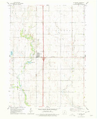 1978 Ellsworth1979 Print · USGSHamilton County farmland meets the river and rail lines of the late seventies, centered on the growing community of Ellsworth. Genealogists and local historians can trace family locations near Homewood Cem or follow the path of the CHICAGO AND NORTH WESTERN railroad along the South Skunk River.
 - 1978 Map of Jewell, 1979 Print
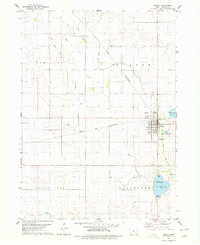 1978 Jewell1979 Print · USGSJewell and the surrounding Hamilton County townships are shown in detail during the late seventies. Genealogists and local historians can trace the town's footprint from Evergreen Cem to the Chicago and North Western rail lines and Little Wall Lake.
End of results
Showing maps 1-2 of 2
Top cities near Jewell Junction
- Webster City historical maps
- Story City historical maps
- Roland historical maps
- Jewell historical maps
- Gilbert historical maps
- Alden historical maps
See more
Top neighborhoods of Jewell Junction
Frequently asked questions
- What are the different types of historical maps available for Jewell Junction?
- What is the oldest map of Jewell Junction?
- Where can I purchase historical maps of Jewell Junction for my home or office?
- Where can I download high-res historical maps of Jewell Junction?
- Are there historical topographic maps available for Jewell Junction?
- Is there historical aerial imagery available for Jewell Junction?
- Where are historical maps of Jewell Junction sourced from?